IMAGES TAKEN NEAR TO
Northfield Road, SAFFRON WALDEN, CB11 3EP
Introduction
This page details the photographs taken nearby to Northfield Road, CB11 3EP by members of the Geograph project.
The Geograph project started in 2005 with the aim of publishing, organising and preserving representative images for every square kilometre of Great Britain, Ireland and the Isle of Man.

There are currently over 7.5m images from over14,400 individuals and you can help contribute to the project by visiting https://www.geograph.org.uk
Image Map (Loading...)


Getting Data...Please wait
Leaflet Map data © OpenStreetMap
Images are licensed for reuse under creativecommons.org/licenses/by-sa/2.0
Notes
- Clicking on the map will re-center to the selected point.
- The higher the marker number, the further away the image location is from the centre of the postcode.
Image Listing (3 Images Found)
Images are licensed for reuse under creativecommons.org/licenses/by-sa/2.0
Image
Details
Distance
1
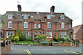
26 to 32 (evens) South Road, Saffron Walden
This was evidently the more well-to-do part of town.
Image: © Robin Webster
Taken: 27 Sep 2014
0.22 miles
3
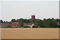
Water Tower in Debden Road, Saffron Walden
Built in 1913 for the Borough of Saffron Walden Water Works. The approximately 28 metres-high red brick Edwardian tower was designed by architect AH Forbes and constructed by local builder J Custerson. It was added to English Heritage’s books as a Grade II listed building on October 31, 1994.
See: https://historicengland.org.uk/listing/the-list/list-entry/1205709
Image: © Chris
Taken: 17 Jul 2017
0.25 miles