IMAGES TAKEN NEAR TO
Peaslands Road, SAFFRON WALDEN, CB11 3EF
Introduction
This page details the photographs taken nearby to Peaslands Road, CB11 3EF by members of the Geograph project.
The Geograph project started in 2005 with the aim of publishing, organising and preserving representative images for every square kilometre of Great Britain, Ireland and the Isle of Man.

There are currently over 7.5m images from over14,400 individuals and you can help contribute to the project by visiting https://www.geograph.org.uk
Image Map
Images are licensed for reuse under creativecommons.org/licenses/by-sa/2.0
Notes
- Clicking on the map will re-center to the selected point.
- The higher the marker number, the further away the image location is from the centre of the postcode.
Image Listing (6 Images Found)
Images are licensed for reuse under creativecommons.org/licenses/by-sa/2.0
Image
Details
Distance
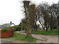
2

Peasland Road
Junction with Thaxted Road.
Image: © Anthony Vosper
Taken: 13 Sep 2021
0.20 miles
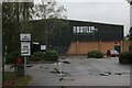
3
Fitness & Leisure Centre
This centre is on Peaslands Road.
Image: © Robert Edwards
Taken: 16 Mar 2007
0.20 miles
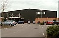
4
Lord Butler Fitness and Leisure Centre
On Peaslands Road in Saffron Walden - offering gym, personal training, swimming, badminton and squash
Image: © Chris Heaton
Taken: 20 Oct 2023
0.20 miles
5
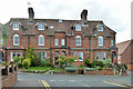
26 to 32 (evens) South Road, Saffron Walden
This was evidently the more well-to-do part of town.
Image: © Robin Webster
Taken: 27 Sep 2014
0.21 miles
6
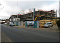
Building Chalk Place
Site for a 5000 sq ft retail showroom with 10 luxury apartments above. The site formerly accommodated a petrol filling station.
Image: © Keith Edkins
Taken: 29 Nov 2017
0.23 miles