IMAGES TAKEN NEAR TO
Upper Green, SAFFRON WALDEN, CB10 2XQ
Introduction
This page details the photographs taken nearby to Upper Green, CB10 2XQ by members of the Geograph project.
The Geograph project started in 2005 with the aim of publishing, organising and preserving representative images for every square kilometre of Great Britain, Ireland and the Isle of Man.

There are currently over 7.5m images from over14,400 individuals and you can help contribute to the project by visiting https://www.geograph.org.uk
Image Map (Loading...)


Getting Data...Please wait
Leaflet Map data © OpenStreetMap
Images are licensed for reuse under creativecommons.org/licenses/by-sa/2.0
Notes
- Clicking on the map will re-center to the selected point.
- The higher the marker number, the further away the image location is from the centre of the postcode.
Image Listing (4 Images Found)
Images are licensed for reuse under creativecommons.org/licenses/by-sa/2.0
Image
Details
Distance
1
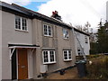
Cottage repairs in Upper Green
Setting up the satellite dish on the chimney.
Image: © Michael Trolove
Taken: 13 Mar 2013
0.07 miles
2
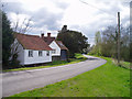
Upper Green, near Tye Green
There are two places called Upper Green marked on the 1:25,000 map within 500 metres of each other. One relates to Wimbish Green and is in TL6035; this one, I presume, belongs to Tye Green to the west. Photo taken at the point where the public footpath leaves the road to the north.
Image: © David Gruar
Taken: 30 Apr 2006
0.14 miles
4
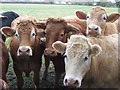
Young Cattle
Young cattle at wimbish Green, Essex.
Image: © Keith Evans
Taken: 28 Feb 2017
0.24 miles