IMAGES TAKEN NEAR TO
Lower Green, SAFFRON WALDEN, CB10 2XH
Introduction
This page details the photographs taken nearby to Lower Green, CB10 2XH by members of the Geograph project.
The Geograph project started in 2005 with the aim of publishing, organising and preserving representative images for every square kilometre of Great Britain, Ireland and the Isle of Man.

There are currently over 7.5m images from over14,400 individuals and you can help contribute to the project by visiting https://www.geograph.org.uk
Image Map (Loading...)


Getting Data...Please wait
Leaflet Map data © OpenStreetMap
Images are licensed for reuse under creativecommons.org/licenses/by-sa/2.0
Notes
- Clicking on the map will re-center to the selected point.
- The higher the marker number, the further away the image location is from the centre of the postcode.
Image Listing (9 Images Found)
Images are licensed for reuse under creativecommons.org/licenses/by-sa/2.0
Image
Details
Distance
2
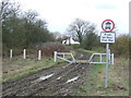
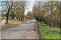
Closed For The Winter
Closed byway near to Wimbish Green, Essex.
Image: © Keith Evans
Taken: 28 Feb 2017
0.12 miles
3
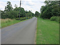
Public footpath on unmade road, Lower Green, Wimbish
Image: © Roger Jones
Taken: 20 Mar 2016
0.14 miles
4
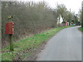
Letterbox And Telephone Box
Letter box and telephone box at Wimbish Green, Essex.
Image: © Keith Evans
Taken: 28 Feb 2017
0.15 miles
5
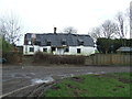
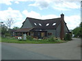
Cottage Gentrification
Cottage gentrification at Wimbish Green, Essex.
Image: © Keith Evans
Taken: 28 Feb 2017
0.16 miles
6
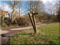
Concrete marker posts at Lower Green
Directional signs in need of a spirit level or at least a man with a tamper.
Image: © Michael Trolove
Taken: 13 Mar 2013
0.22 miles
7
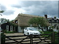
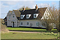
Thatched cottage, Wimbish Green
On Top Road.
Image: © JThomas
Taken: 20 May 2017
0.24 miles