
IMAGES TAKEN NEAR TO
Colyn Place, SAFFRON WALDEN, CB10 2DD
Introduction
This page details the photographs taken nearby to Colyn Place, CB10 2DD by members of the Geograph project.
The Geograph project started in 2005 with the aim of publishing, organising and preserving representative images for every square kilometre of Great Britain, Ireland and the Isle of Man.

There are currently over 7.5m images from over14,400 individuals and you can help contribute to the project by visiting https://www.geograph.org.uk
Image Map
Images are licensed for reuse under creativecommons.org/licenses/by-sa/2.0
Notes
- Clicking on the map will re-center to the selected point.
- The higher the marker number, the further away the image location is from the centre of the postcode.
Image Listing (18 Images Found)
Images are licensed for reuse under creativecommons.org/licenses/by-sa/2.0
Image
Details
Distance
1
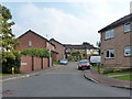
Doddenhill Close, Saffron Walden
In the comparatively recent residential expansion north of the old town.
Image: © Robin Webster
Taken: 3 Oct 2015
0.06 miles
3
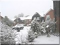
Snow on Thorncroft
This photo shows a residential cul-de-sac in Saffron Walden in north-west Essex in February 2007. We awoke to find that it had snowed overnight. With global warming days like this in this part of the country are now less common; by afternoon most of the snow had melted. This road is where the urban area meets the rural area. The back garden of the house is bounded on two sides by a hedgerow and footpath that follow the Saxon Parish boundary. Beyond the footpath arable field stretch for several miles to the nearest villages.
Image: © Alan Hawkes
Taken: 8 Feb 2007
0.15 miles
4
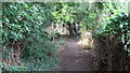
Footpath
This footpath links Whiteshot Way to Buckenhoe Road. A short distance north it links with the Harcamlow Way: a network of footpaths from Harlow to Cambridge. The hedgerow to the left, or west, appears on maps in the County archives and probably marks the boundary of the parish at least from medieval times. It contains a wide range of species such as spindle and wayfarer.
Image: © Alan Hawkes
Taken: 27 Jul 2008
0.17 miles
5
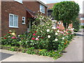
Roses on mid-Summer Day
How a smallish front garden can be a wealth of colour and scent.
Image: © Alan Hawkes
Taken: 21 Jun 2009
0.17 miles
6
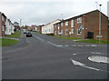
Goddard Way
Mid-1970s estate off Little Walden Road
Image: © Keith Edkins
Taken: 29 Nov 2017
0.20 miles
8
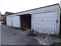
Garages lane to Copthall Cottages
These garages are on a lane that leads from Ashdon Road to houses known as Copthall Cottages.
Image: © Alan Hawkes
Taken: 9 Jun 2014
0.21 miles
9
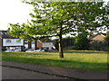
Open space with potential for play
This piece of land is on the junction of Dawson Way and Thorncroft. When Thorncroft was built this was left as a play area for children. The developer left it as rough land. Vegetation moved in and local children, both boys and girls, developed imaginative games. A local busybody kept pressuring the developer to do something with it. The developer returned, levelled the land and erected two sets of small goalposts - the cheapest option. The consequence was that boys played football, girls were banished and imaginative options lost. The local authority financial cuts have meant that the grass has been allowed to grow and a wild-flower meadow is beginning to emerge.
Image: © Alan Hawkes
Taken: 9 Jun 2014
0.21 miles
10
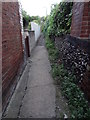
Passageway between houses
This passageway runs between two houses. It gives access to rear gardens.
Image: © Alan Hawkes
Taken: 9 Jun 2014
0.21 miles