IMAGES TAKEN NEAR TO
Petts Lane, SAFFRON WALDEN, CB10 1XH
Introduction
This page details the photographs taken nearby to Petts Lane, CB10 1XH by members of the Geograph project.
The Geograph project started in 2005 with the aim of publishing, organising and preserving representative images for every square kilometre of Great Britain, Ireland and the Isle of Man.

There are currently over 7.5m images from over14,400 individuals and you can help contribute to the project by visiting https://www.geograph.org.uk
Image Map
Images are licensed for reuse under creativecommons.org/licenses/by-sa/2.0
Notes
- Clicking on the map will re-center to the selected point.
- The higher the marker number, the further away the image location is from the centre of the postcode.
Image Listing (25 Images Found)
Images are licensed for reuse under creativecommons.org/licenses/by-sa/2.0
Image
Details
Distance
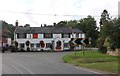
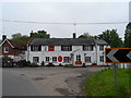
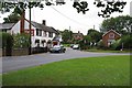
1
The Crown public house at Little Walden
Image: © Adrian S Pye
Taken: 10 Aug 2020
0.07 miles
2
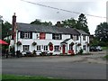
The Crown
The Crown public house at Little Walden, Essex.
Image: © Keith Evans
Taken: 25 Jul 2017
0.07 miles
5
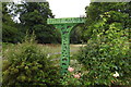
Little Walden village sign
Featuring aircraft representing the USAAF wartime airfield and birds and various animals representing the agricultural nature and heritage of the village.
Whether or not the crown, hooked over the top right, is original or not, is debatable, but would represent the public house opposite https://www.geograph.org.uk/photo/6565023
Image: © Adrian S Pye
Taken: 10 Aug 2020
0.08 miles
6
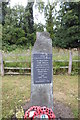
Memorial to the USAAF airbase at Little Walden
The memorial includes those who served in both World Wars as well as the men and women who served at Little Walden airfield.
The airfield wass built specifically as a USAAF Medium Bomber / Fighter station, 1943-44.
03/1944 to 09/1944, 409th Bombardment Group flying A-20 Havocs, flew missions in support of the Allied invasion of Normandy then moved to France.
09/1944 to 12/1944, three squadrons of the 361st Fighter Group "The Yellow Jackets" flying P-51 Mustangs.
09/1945 to 11/1945, three Fighter Squadrons of the 56th Fighter Group.
The airfield closed in 1958 and was sold in 1960 and returned mainly to agriculture.
The control tower, now used as offices can be seen here https://www.geograph.org.uk/photo/6564994
Image: © Adrian S Pye
Taken: 10 Aug 2020
0.08 miles
7
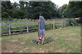
Memorial to USAAF Little Walden
The memorial includes those who served in both World Wars as well as the men and women who served at Little Walden airfield.
The airfield was built specifically as a USAAF Medium Bomber / Fighter station, 1943-44.
03/1944 to 09/1944, 409th Bombardment Group flying A-20 Havocs, flew missions in support of the Allied invasion of Normandy then moved to France.
09/1944 to 12/1944, three squadrons of the 361st Fighter Group "The Yellow Jackets" flying P-51 Mustangs.
09/1945 to 11/1945, three Fighter Squadrons of the 56th Fighter Group.
The airfield closed in 1958 and was sold in 1960 and returned mainly to agriculture.
The control tower, now used as offices can be seen here https://www.geograph.org.uk/photo/6564994
Image: © Adrian S Pye
Taken: 10 Aug 2020
0.08 miles
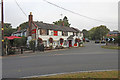
8
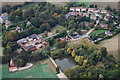
Little Walden from the air
Taken from approx 1300 feet with Nikon D40X
Image: © Mike Naylor
Taken: 13 Oct 2007
0.08 miles
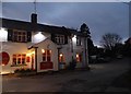
9
The Crown
The Image a Good Beer Guide free House stands on a bend in the B1052
Image: © Glyn Baker
Taken: 28 Aug 2009
0.08 miles