IMAGES TAKEN NEAR TO
Castle Carrock, BRAMPTON, CA8 9NQ
Introduction
This page details the photographs taken nearby to CA8 9NQ by members of the Geograph project.
The Geograph project started in 2005 with the aim of publishing, organising and preserving representative images for every square kilometre of Great Britain, Ireland and the Isle of Man.

There are currently over 7.5m images from over14,400 individuals and you can help contribute to the project by visiting https://www.geograph.org.uk
Image Map
Images are licensed for reuse under creativecommons.org/licenses/by-sa/2.0
Notes
- Clicking on the map will re-center to the selected point.
- The higher the marker number, the further away the image location is from the centre of the postcode.
Image Listing (11 Images Found)
Images are licensed for reuse under creativecommons.org/licenses/by-sa/2.0
Image
Details
Distance
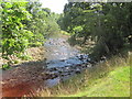
2
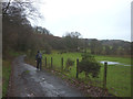
Stone Stile
Footpath to River Gelt from Greenwell village.
Image: © mauldy
Taken: 9 Aug 2006
0.08 miles
5
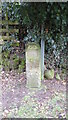
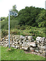
Commemorative Marker at Greenwell
Millennium stone beside the drive and bridleway at Greenwell. On the boundary of Hayton and Castle Carrock parishes. Inscribed Hayton PC / M M.
Milestone Society National ID: CU_HAYCCA01cm
Image: © Mike Rayner
Taken: 12 Mar 2023
0.13 miles
6
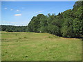
Footpath through Farmland near The River Gelt
Image: © Les Hull
Taken: 12 Aug 2015
0.14 miles
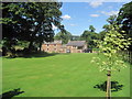
9
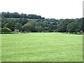
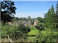
Meadow by the River Gelt
Gelt Mill can be seen in the trees.
Image: © Oliver Dixon
Taken: 7 Aug 2020
0.16 miles