IMAGES TAKEN NEAR TO
How Mill, BRAMPTON, CA8 9JL
Introduction
This page details the photographs taken nearby to CA8 9JL by members of the Geograph project.
The Geograph project started in 2005 with the aim of publishing, organising and preserving representative images for every square kilometre of Great Britain, Ireland and the Isle of Man.

There are currently over 7.5m images from over14,400 individuals and you can help contribute to the project by visiting https://www.geograph.org.uk
Image Map
Images are licensed for reuse under creativecommons.org/licenses/by-sa/2.0
Notes
- Clicking on the map will re-center to the selected point.
- The higher the marker number, the further away the image location is from the centre of the postcode.
Image Listing (11 Images Found)
Images are licensed for reuse under creativecommons.org/licenses/by-sa/2.0
Image
Details
Distance
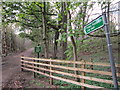
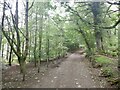
3
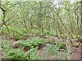
Cowran Woods
North of the railway cutting.
Image: © Richard Webb
Taken: 11 Jun 2021
0.20 miles
8
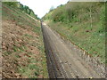
Cowran Cutting
The Carlisle to Newcastle line.
At one time this was the deepest cutting in the country.
Image: © Malcolm Jones
Taken: 4 May 2005
0.22 miles
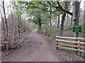
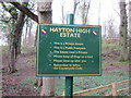
10
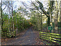
Estate road in Tootop Woods
Part of the Hayton High Estate. To read what it says on the notice, see Image
Image: © Oliver Dixon
Taken: 5 Nov 2014
0.23 miles