IMAGES TAKEN NEAR TO
Hayton, BRAMPTON, CA8 9JE
Introduction
This page details the photographs taken nearby to CA8 9JE by members of the Geograph project.
The Geograph project started in 2005 with the aim of publishing, organising and preserving representative images for every square kilometre of Great Britain, Ireland and the Isle of Man.

There are currently over 7.5m images from over14,400 individuals and you can help contribute to the project by visiting https://www.geograph.org.uk
Image Map
Images are licensed for reuse under creativecommons.org/licenses/by-sa/2.0
Notes
- Clicking on the map will re-center to the selected point.
- The higher the marker number, the further away the image location is from the centre of the postcode.
Image Listing (14 Images Found)
Images are licensed for reuse under creativecommons.org/licenses/by-sa/2.0
Image
Details
Distance
1
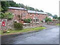
Stone House, Hayton
Stone House was the home of two senior military men of the 19th century - Field Marshal Sir Hew Dalrymple Ross (1779–1868) and General Sir John Ross (1829–1905).
Image: © Oliver Dixon
Taken: 5 Nov 2014
0.02 miles
2
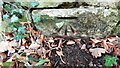
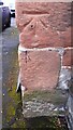
Benchmark on stone in wall on south side of road
Ordnance Survey cut mark benchmark levelled at 87.521m above Newlyn Datum verified 1972
Image: © Roger Templeman
Taken: 8 Feb 2023
0.12 miles
3
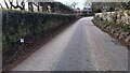
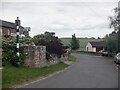
Looking west along road at east end of Hayton
There is an Ordnance Survey benchmark Image on a stone at the base of the wall on the left hand side of the road where a street atlas book has been placed
Image: © Roger Templeman
Taken: 8 Feb 2023
0.14 miles
4
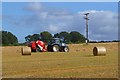
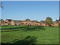
Farmland, Hayton
Straw being baled to the east of the village.
Image: © Andrew Smith
Taken: 5 Sep 2012
0.16 miles
5
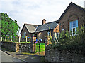
Hayton Reading Room
The original building, on the left, dates from 1925. The gable end to the right is part of an extension which opened in 2011 (Cumberland News http://www.cumberlandnews.co.uk/news/Hayton-villagers-delighted-with-new-community-hall-5373b5c7-78b7-433c-971f-948fe00d5788-ds ).
The Reading Room was built in memory of Robert Ormston Lamb, with money bequeathed by his son, Everard Joseph Lamb. The family resided at Hayton House, a mansion since demolished, which was just up the road from here. EJ Lamb was killed in action in 1914 http://www.rytonwarmemorials.org.uk/war_memorials/225/everard-joseph-lamb.php .
Image: © Rose and Trev Clough
Taken: 23 Aug 2015
0.19 miles
6
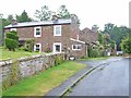
Roses round the door
Cottages at Townhead, Hayton
Image: © Oliver Dixon
Taken: 20 Jul 2006
0.21 miles
7
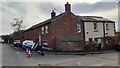
Elmfield and Woodbine Cottage at T-junction in Townhead
There is an Ordnance Survey benchmark Image on the corner of the near house left of its stone extension
Image: © Roger Templeman
Taken: 8 Feb 2023
0.22 miles
9
Cut mark on NE corner of Elmfield
Ordnance Survey cut mark benchmark levelled at 98.185m verified 1972
Image: © Roger Templeman
Taken: 8 Feb 2023
0.23 miles