IMAGES TAKEN NEAR TO
Brier Close, BRAMPTON, CA8 9HX
Introduction
This page details the photographs taken nearby to Brier Close, CA8 9HX by members of the Geograph project.
The Geograph project started in 2005 with the aim of publishing, organising and preserving representative images for every square kilometre of Great Britain, Ireland and the Isle of Man.

There are currently over 7.5m images from over14,400 individuals and you can help contribute to the project by visiting https://www.geograph.org.uk
Image Map
Images are licensed for reuse under creativecommons.org/licenses/by-sa/2.0
Notes
- Clicking on the map will re-center to the selected point.
- The higher the marker number, the further away the image location is from the centre of the postcode.
Image Listing (46 Images Found)
Images are licensed for reuse under creativecommons.org/licenses/by-sa/2.0
Image
Details
Distance
1
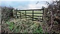
Gateway to field on SW side of Brier Lonning
There is an Ordnance Survey benchmark Image on the inside face of the left hand gatepost
Image: © Roger Templeman
Taken: 22 Dec 2022
0.12 miles
2
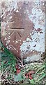
Benchmark on gatepost at field gateway on SW side of Brier Lonning
Ordnance Survey cut mark benchmark levelled at 60.787m above Newlyn Datum verified 1972
Image: © Roger Templeman
Taken: 22 Dec 2022
0.13 miles
3
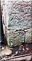
Benchmark on NW corner of Blacksmith's Cottage
Weathered cut mark benchmark abandoned by the Ordnance Survey but shown as levelled at 214.9 feet above Liverpool Datum on old maps
Image: © Roger Templeman
Taken: 22 Dec 2022
0.13 miles
4
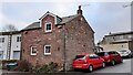
Blacksmith's Cottage on street corner in Hayton
There is an Ordnance Survey benchmark Image on the corner, right hand face, of the house
Image: © Roger Templeman
Taken: 22 Dec 2022
0.14 miles
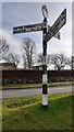
6

Entering Hayton from the west at Fenton Gate T-junction
There is a Cumberland County Council signpost Image on the verge at the junction
Image: © Luke Shaw
Taken: 8 Feb 2023
0.16 miles
7
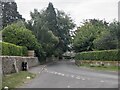
East-west road through Hayton passing Townfoot House on the left
There is an Ordnance Survey benchmark Image on the wall on the left hand side of the road close to the hydrant post
Image: © Roger Templeman
Taken: 8 Feb 2023
0.16 miles
8
Cumberland County Council at T-junction at west end of Hayton
Image: © Luke Shaw
Taken: 8 Feb 2023
0.16 miles
9
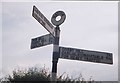
Old Direction Sign - Signpost by Fenton Gate, Hayton
Annulus finial - 3 arms; Cumberland named halo by the UC road, in parish of Hayton (Carlisle District), Fenton Gate.
Surveyed
Milestone Society National ID: CU_NY5057A.
Image: © I Davison
Taken: Unknown
0.16 miles
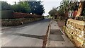
10

Benchmark on wall on south side of road outside Townfoot House
Ordnance Survey cut mark benchmark levelled at 69.072m above Newlyn Datum
Image: © Roger Templeman
Taken: 8 Feb 2023
0.16 miles