IMAGES TAKEN NEAR TO
Hayton, BRAMPTON, CA8 9HU
Introduction
This page details the photographs taken nearby to CA8 9HU by members of the Geograph project.
The Geograph project started in 2005 with the aim of publishing, organising and preserving representative images for every square kilometre of Great Britain, Ireland and the Isle of Man.

There are currently over 7.5m images from over14,400 individuals and you can help contribute to the project by visiting https://www.geograph.org.uk
Image Map
Images are licensed for reuse under creativecommons.org/licenses/by-sa/2.0
Notes
- Clicking on the map will re-center to the selected point.
- The higher the marker number, the further away the image location is from the centre of the postcode.
Image Listing (8 Images Found)
Images are licensed for reuse under creativecommons.org/licenses/by-sa/2.0
Image
Details
Distance
4
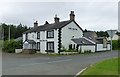
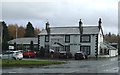
Lane End Inn
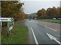
Where the minor road from Hayton joins the A69.
Not many signs of life at the inn!
Image: © Russel Wills
Taken: 6 Jun 2018
0.09 miles
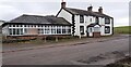
5
Lane End Inn
There is an Ordnance Survey benchmark Image on a black-painted quoin on the near corner, right hand face, of the inn
Image: © Roger Templeman
Taken: 23 Feb 2023
0.09 miles
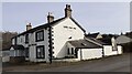
6
Lane End Inn and restaurant on SE side of A69
Image: © Luke Shaw
Taken: 23 Feb 2023
0.09 miles
7
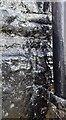
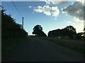
Overpainted benchmark on NW corner of the Land End Inn
Ordnance Survey cut mark benchmark levelled at 63.635m above Newlyn Datum verified 1972
Image: © Roger Templeman
Taken: 23 Feb 2023
0.09 miles