IMAGES TAKEN NEAR TO
Hayton, BRAMPTON, CA8 9HT
Introduction
This page details the photographs taken nearby to CA8 9HT by members of the Geograph project.
The Geograph project started in 2005 with the aim of publishing, organising and preserving representative images for every square kilometre of Great Britain, Ireland and the Isle of Man.

There are currently over 7.5m images from over14,400 individuals and you can help contribute to the project by visiting https://www.geograph.org.uk
Image Map
Images are licensed for reuse under creativecommons.org/licenses/by-sa/2.0
Notes
- Clicking on the map will re-center to the selected point.
- The higher the marker number, the further away the image location is from the centre of the postcode.
Image Listing (44 Images Found)
Images are licensed for reuse under creativecommons.org/licenses/by-sa/2.0
Image
Details
Distance
1
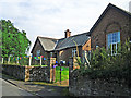
Hayton Reading Room
The original building, on the left, dates from 1925. The gable end to the right is part of an extension which opened in 2011 (Cumberland News http://www.cumberlandnews.co.uk/news/Hayton-villagers-delighted-with-new-community-hall-5373b5c7-78b7-433c-971f-948fe00d5788-ds ).
The Reading Room was built in memory of Robert Ormston Lamb, with money bequeathed by his son, Everard Joseph Lamb. The family resided at Hayton House, a mansion since demolished, which was just up the road from here. EJ Lamb was killed in action in 1914 http://www.rytonwarmemorials.org.uk/war_memorials/225/everard-joseph-lamb.php .
Image: © Rose and Trev Clough
Taken: 23 Aug 2015
0.03 miles
2
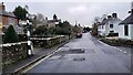
Village street, Hayton
The road is followed by Hadrian's Cycleway (National Cycle Network route 72).
Image: © Oliver Dixon
Taken: 5 Nov 2014
0.07 miles
3

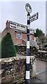
Direction Sign ? Signpost in Hayton village
Located on the south side of a T junction in the village, Hayton parish. 3 arms and annulus finial. See also http://www.geog.port.ac.uk/webmap/thelakes/photos/buz73.jpg.
Milestone Society National ID: CU_NY5057D
Image: © J Kelly
Taken: Unknown
0.07 miles
4
Cumberland County Council finger signpost at T-junction
Image: © Roger Templeman
Taken: 22 Dec 2022
0.07 miles
5
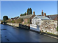
Looking west along road at east end of Hayton
There is an Ordnance Survey benchmark Image on a stone at the base of the wall on the left hand side of the road where a street atlas book has been placed
Image: © Roger Templeman
Taken: 8 Feb 2023
0.09 miles
6
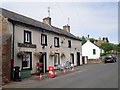
Hayton Stores
Taken on a day when lots of visitors were in the village for an Open Gardens event, which could explain the traffic cones.
There used to be a Post Office here, but it was closed during the P.O. "Network Change" of 2008.
Image: © Rose and Trev Clough
Taken: 20 Jun 2010
0.10 miles
7
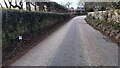
Looking west along Fenton Gate at T-junction
Image: © Roger Templeman
Taken: 22 Dec 2022
0.10 miles
8
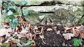
Benchmark on stone in wall on south side of road
Ordnance Survey cut mark benchmark levelled at 87.521m above Newlyn Datum verified 1972
Image: © Roger Templeman
Taken: 8 Feb 2023
0.11 miles
9
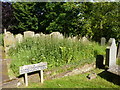
A good reason for not cutting the grass
Image: © Alexander P Kapp
Taken: 16 Jun 2011
0.12 miles
10
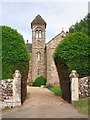
The tower of Norman House
A private house, built in the late 1860s or early 1870s by one of the Graham family of nearby Edmond Castle http://www.imagesofengland.org.uk/details/default.aspx?id=78040 .
Image: © Rose and Trev Clough
Taken: 20 Jun 2010
0.12 miles