IMAGES TAKEN NEAR TO
Heads Nook, BRAMPTON, CA8 9AY
Introduction
This page details the photographs taken nearby to CA8 9AY by members of the Geograph project.
The Geograph project started in 2005 with the aim of publishing, organising and preserving representative images for every square kilometre of Great Britain, Ireland and the Isle of Man.

There are currently over 7.5m images from over14,400 individuals and you can help contribute to the project by visiting https://www.geograph.org.uk
Image Map
Images are licensed for reuse under creativecommons.org/licenses/by-sa/2.0
Notes
- Clicking on the map will re-center to the selected point.
- The higher the marker number, the further away the image location is from the centre of the postcode.
Image Listing (8 Images Found)
Images are licensed for reuse under creativecommons.org/licenses/by-sa/2.0
Image
Details
Distance
1
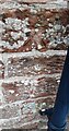
Benchmark on SW face of Corry House
Ordnance Survey cut mark benchmark levelled at 52.838m above Newlyn Datum verified in 1972 but shown as deleted on the OS Archive Benchmark Database: it is still there!
Image: © Roger Templeman
Taken: 26 Jan 2023
0.01 miles
2
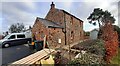
Corry House
There is an Ordnance Survey benchmark Image on the right hand face of the house on the near side of the black downpipe
Image: © Roger Templeman
Taken: 26 Jan 2023
0.02 miles
5
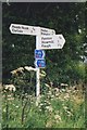
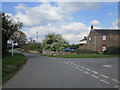
Old Direction Sign - Signpost by Corry House, Hayton parish
No finial - 3 arms; Cumbria modern by the UC road, in parish of Hayton (Carlisle District), by Corry House.
Surveyed
Milestone Society National ID: CU_NY4956
Image: © Milestone Society
Taken: Unknown
0.02 miles
6
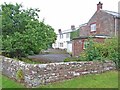
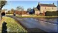
Ashview, near Heads Nook
With adjoining cottage. Ashview is the white house.
Image: © Oliver Dixon
Taken: 20 Jul 2006
0.05 miles
7
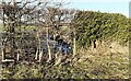
Trout Beck viewed through roadside hedge at Allenwood
There is an Ordnance Survey benchmark Image at the middle of the bridge parapet where a patch of ivy has been removed
Image: © Roger Templeman
Taken: 20 Jan 2023
0.21 miles
8
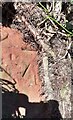
Benchmark on north parapet of bridge over Trout Beck
Ordnance Survey cut mark, partly hidden by ivy, levelled at 52.360m above Newlyn Datum verified 1972
Image: © Roger Templeman
Taken: 20 Jan 2023
0.22 miles