IMAGES TAKEN NEAR TO
Allengrove, BRAMPTON, CA8 9AP
Introduction
This page details the photographs taken nearby to Allengrove, CA8 9AP by members of the Geograph project.
The Geograph project started in 2005 with the aim of publishing, organising and preserving representative images for every square kilometre of Great Britain, Ireland and the Isle of Man.

There are currently over 7.5m images from over14,400 individuals and you can help contribute to the project by visiting https://www.geograph.org.uk
Image Map (Loading...)


Getting Data...Please wait
Leaflet Map data © OpenStreetMap
Images are licensed for reuse under creativecommons.org/licenses/by-sa/2.0
Notes
- Clicking on the map will re-center to the selected point.
- The higher the marker number, the further away the image location is from the centre of the postcode.
Image Listing (12 Images Found)
Images are licensed for reuse under creativecommons.org/licenses/by-sa/2.0
Image
Details
Distance
1
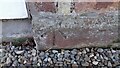
Benchmark on house 'Allengrove'
Ordnance Survey pivot benchmark levelled at 36.298m above Newlyn Datum verified 1972
Image: © Roger Templeman
Taken: 12 Dec 2022
0.01 miles
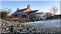
2
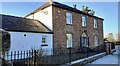
'Allengrove' on SW side of minor road SE of Corby Hill
There is an Ordnance Survey benchmark Image on the stone at the base of the house at its near corner (at the junction with the attached single storey extension)
Image: © Roger Templeman
Taken: 12 Dec 2022
0.01 miles
3
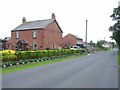
Applegarth Farm near Warwick Bridge
Allengrove House in the distance
Image: © Oliver Dixon
Taken: 20 Jul 2006
0.14 miles
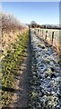
5
Gate and stone step stile across footpath from Allen Grove to Warwick Mill
Image: © Luke Shaw
Taken: 12 Dec 2022
0.17 miles
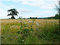
6
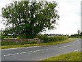
Bridge over the Trout Beck
Approaching Corby Hill on the road from Heads Nook.
Image: © Rose and Trev Clough
Taken: 4 Jul 2009
0.18 miles
7
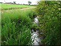
The Trout Beck near Corby Hill
Looking downstream from the road bridge, with Longthwaite Farm over to the left. There are several other streams called "Trout Beck" in Cumbria.
Image: © Rose and Trev Clough
Taken: 4 Jul 2009
0.19 miles
8
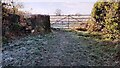
A frosty footpath between Warwick Mill and Allen Grove
Image: © Roger Templeman
Taken: 12 Dec 2022
0.20 miles
9
Troutbeck Cottage on south side of road east of Corby Hill
There is an Ordnance Survey benchmark Image on the near corner of the main section of the house
Image: © Roger Templeman
Taken: 12 Dec 2022
0.20 miles
10

Benchmark on quoin of Troutbeck Cottage on south side of road
Ordnance Survey cut mark benchmark levelled at 36.298m above Newlyn Datum verified 1972
Image: © Roger Templeman
Taken: 12 Dec 2022
0.21 miles