IMAGES TAKEN NEAR TO
Slaggyford, BRAMPTON, CA8 7PF
Introduction
This page details the photographs taken nearby to CA8 7PF by members of the Geograph project.
The Geograph project started in 2005 with the aim of publishing, organising and preserving representative images for every square kilometre of Great Britain, Ireland and the Isle of Man.

There are currently over 7.5m images from over14,400 individuals and you can help contribute to the project by visiting https://www.geograph.org.uk
Image Map
Images are licensed for reuse under creativecommons.org/licenses/by-sa/2.0
Notes
- Clicking on the map will re-center to the selected point.
- The higher the marker number, the further away the image location is from the centre of the postcode.
Image Listing (14 Images Found)
Images are licensed for reuse under creativecommons.org/licenses/by-sa/2.0
Image
Details
Distance
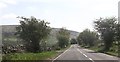
1
Entrance to Softley Farm
The small bridge at the bottom of the track crosses a disused railway.
Image: © Stuart Logan
Taken: 13 Sep 2003
0.02 miles
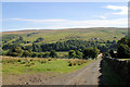
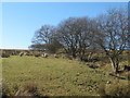
2
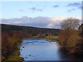
The valley of the River South Tyne around Softley Farm
Image: © Mike Quinn
Taken: 23 Oct 2007
0.02 miles
4
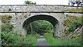
Bridge over Haltwhistle to Alston branch line at Softley
Image: © Sandy Gerrard
Taken: 19 Sep 2021
0.03 miles
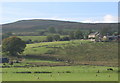
6
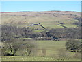
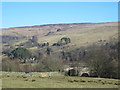
The valley of the River South Tyne around Knowe Head
Image: © Mike Quinn
Taken: 27 Feb 2013
0.16 miles
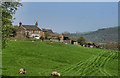
7
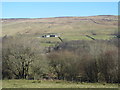
The valley of the River South Tyne north of Knaresdale Hall
Image: © Mike Quinn
Taken: 27 Feb 2013
0.16 miles
10
The valley of the River South Tyne around Softley
The bridge carries the farm track over the (former) Haltwhistle to Alston branch line https://www.south-tynedale-railway.org.uk .
Image: © Mike Quinn
Taken: 27 Feb 2013
0.22 miles