IMAGES TAKEN NEAR TO
Midgeholme, Lambley, BRAMPTON, CA8 7NB
Introduction
This page details the photographs taken nearby to CA8 7NB by members of the Geograph project.
The Geograph project started in 2005 with the aim of publishing, organising and preserving representative images for every square kilometre of Great Britain, Ireland and the Isle of Man.

There are currently over 7.5m images from over14,400 individuals and you can help contribute to the project by visiting https://www.geograph.org.uk
Image Map
Images are licensed for reuse under creativecommons.org/licenses/by-sa/2.0
Notes
- Clicking on the map will re-center to the selected point.
- The higher the marker number, the further away the image location is from the centre of the postcode.
Image Listing (18 Images Found)
Images are licensed for reuse under creativecommons.org/licenses/by-sa/2.0
Image
Details
Distance
1
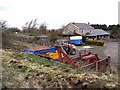
Loading bay on "Lord Carlisle's Railway"
"Lord Carlisle's Railway" was built south-eastwards from Brampton to serve the various mines and works in the area towards the South Tyne. Coal from nearby collieries was loaded onto wagons at the old loading bay which can be seen to the left..
Image: © Oliver Dixon
Taken: 27 Apr 2010
0.03 miles
2
Loading bay on "Lord Carlisle's Railway"
"Lord Carlisle's Railway" was built south-eastwards from Brampton to serve the various mines and works in the area towards the South Tyne. Coal from nearby collieries was loaded onto wagons at this old loading bay.
Image: © Oliver Dixon
Taken: 27 Apr 2010
0.04 miles
3

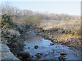
Midgeholme & Haltonlea West Fell above Midgeholme
Looking down the steep fellside towards the A689 and Lord Carlisle's Railway on an embankment across the valley of Black Burn.
The (former) railway, part of which was in use in the 18th C, was built by Lord Carlisle without an Act of Parliament as it was built on his own land. It carried coal from the various collieries along the line of what is now the A689 to Brampton. By the mid-19th C, the line connected the Haltwhistle to Alston line (at Lambley) with Brampton on the Newcastle to Carlisle line. It was one of the first non-Stephenson railways to convert and adopt the standard gauge of 4’8½" and in 1836 the ‘new railway’ opened officially under steam traction with the Rocket http://www.bbc.co.uk/history/british/victorians/launch_ani_rocket.shtml in use from the following year. For more info see http://www.cumbria-railways.co.uk/brampton_railway.html. See also Image and Image
Image: © Mike Quinn
Taken: 18 Feb 2013
0.08 miles
5
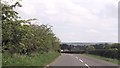
Midgeholme
Route 72 of the National Cycle Network near Midgholme. The trackbed of the dismantled Brampton to Lambley Railway runs in the cutting to the right.
Image: © Peter McDermott
Taken: 12 Sep 2009
0.11 miles
6
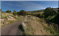
Winding road parallel to old railway track
Image: © John Firth
Taken: 18 May 2014
0.11 miles
7
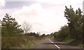
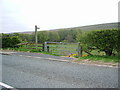
A683 at footpath near Midgeholme Bridge
Footpath sign can be seen to the right
Image: © John Firth
Taken: 18 May 2014
0.15 miles
9
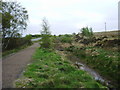
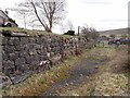
Dismantled Railway
This is part of the Brampton to Lambley railway (Lord Carlisle's Railway) and was built to service the various mines and works which existed in the 1800s. The line was started in the late 1700s at the western end and was finished in the mid 1800s at Lambley when it was connect to the Alston line. The line had a passenger service in the mid 1800s and again in the 1910s and was eventually closed by the NCB in 1953 and pulled up.
Image: © Alexander P Kapp
Taken: 4 May 2007
0.18 miles