IMAGES TAKEN NEAR TO
Lambley, BRAMPTON, CA8 7LL
Introduction
This page details the photographs taken nearby to CA8 7LL by members of the Geograph project.
The Geograph project started in 2005 with the aim of publishing, organising and preserving representative images for every square kilometre of Great Britain, Ireland and the Isle of Man.

There are currently over 7.5m images from over14,400 individuals and you can help contribute to the project by visiting https://www.geograph.org.uk
Image Map
Images are licensed for reuse under creativecommons.org/licenses/by-sa/2.0
Notes
- Clicking on the map will re-center to the selected point.
- The higher the marker number, the further away the image location is from the centre of the postcode.
Image Listing (63 Images Found)
Images are licensed for reuse under creativecommons.org/licenses/by-sa/2.0
Image
Details
Distance
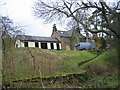
1
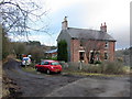
Railway Cottages south of Lambley Station
There is a fine view of the viaduct from the right side of the houses Image
The two semi-detached houses are shown as Railway Cottages on the 1896 OS map and may have provided accommodation for railway signalmen and porters at Lambley Station which is just along the old trackbed on the left. The track to the right descends to Waughold Holme. Access down Bowden's Banks from the road to the west was originally via a track which crossed the railway on a bridge (now demolished) further south.
Image: © Andrew Curtis
Taken: 18 Feb 2015
0.01 miles
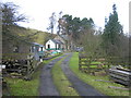
2
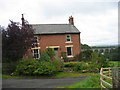
Railway Cottages
Not certain of the name of these cottages but they are up the bank from Waughold Holme. They may have been railworkers cottages when the Haltwhistle to Alston line was running.
I think these cottages are called "Old Railway Cottages". Until fairly recently (and maybe still) they were occupied by a botanist. Information supplied by Helen Pearson.
Image: © Les Hull
Taken: 24 Sep 2008
0.01 miles
3
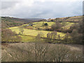
Western slopes of the South Tyne valley above Lambley Viaduct
As viewed from the top of the viaduct: pasture land around Waughold Holme.
Image: © Andy Parrett
Taken: 3 Apr 2010
0.04 miles
4
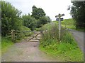
South Tyne Trail near Lambley
Trackbed of the old railway which once ran from Haltwhistle to Alston http://www.visitcumbria.com/pen/haltalst.htm http://www.railbrit.co.uk/Alston_Branch/frame.htm. Built in 1846, the line was recommended for closure by Beeching but was reprieved because there was no adequate road access to Alston in the worst of winter weather. The line was eventually closed in 1976. Much of the line now forms part of the South Tyne Trail for walkers and cyclists http://www.northpennines.org.uk/index.cfm?articleid=5187. The Trail is also followed some of the way by the Pennine Cycleway, route 68 of the National Cycle Network http://www.cycle-routes.org/penninecycleway/.
About 200m to the north of this point, the continuity of the track is interrupted by a private garden which prevents access to the magnificent Lambley Viaduct from the south. The Pennine Cycleway has therefore at this point to climb up to join the A689 seen to the right of the junction.
Image: © Oliver Dixon
Taken: 15 Jul 2008
0.05 miles
5
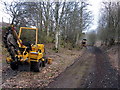
Laying fibre-optic cable beside trackbed of Alston Railway, Bowden's Banks
See description here Image]
Image: © Andrew Curtis
Taken: 18 Feb 2015
0.06 miles
6
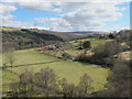
Waughold Holme
Photo taken from Lambley viaduct http://ds.dial.pipex.com/town/lane/jy40/page47.html.
Image: © Mike Quinn
Taken: 19 Apr 2013
0.07 miles
7
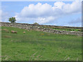
Field with lapwing, Lambley
The black-and-white spot in the centre of the picture is a lapwing (peewit), one of several we saw in the fields around here.
Image: © Stephen Craven
Taken: 20 May 2007
0.12 miles
8
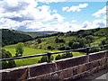
View From Lambley Viaduct
Looking at Waughold Holme, from Lambley Viaduct. This section of cycle route 72 ends on the viaduct, to continue following the old Haltwhistle - Alston railway line, you need to back track about 1km and follow cycle route 68 onto A689, head south and join the old railway line just pass the right hand building in the picture. Lambley Viaduct is well worth the detour.
Image: © Chris McAuley
Taken: 29 Jul 2007
0.13 miles
9
Lambley Station, (Haltwhistle - Alston)
Lambley Station was opened on 21st May 1952 and closed to passengers on 3rd May 1976 and to goods on 12 September 1960. The station was staffed until 1966. The station house is now a private house.
Image: © Les Hull
Taken: 10 Feb 2005
0.14 miles
10
Lambley Station, ( Haltwhistle - Alston)
For more information on the station, with photographs of it before and after closure, and a history of the railway line see http://www.disused-stations.org.uk/l/lambley/index.shtml
Image: © Les Hull
Taken: 10 Feb 2005
0.14 miles