IMAGES TAKEN NEAR TO
Greenhead, BRAMPTON, CA8 7JS
Introduction
This page details the photographs taken nearby to CA8 7JS by members of the Geograph project.
The Geograph project started in 2005 with the aim of publishing, organising and preserving representative images for every square kilometre of Great Britain, Ireland and the Isle of Man.

There are currently over 7.5m images from over14,400 individuals and you can help contribute to the project by visiting https://www.geograph.org.uk
Image Map
Images are licensed for reuse under creativecommons.org/licenses/by-sa/2.0
Notes
- Clicking on the map will re-center to the selected point.
- The higher the marker number, the further away the image location is from the centre of the postcode.
Image Listing (14 Images Found)
Images are licensed for reuse under creativecommons.org/licenses/by-sa/2.0
Image
Details
Distance
1
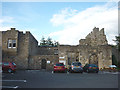
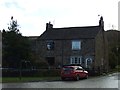
Car park and ruins, Blenkinsopp Castle
The castle ruins have been conserved and are part of a holiday park.
Image: © Karl and Ali
Taken: 4 Sep 2011
0.04 miles
2
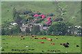
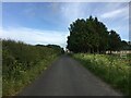
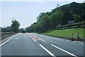
Blenkinsopp
Blenkinsopp is a small hamlet near Greenhead and just off the A69 Trunk Road. Blenkinsopp Castle can be seen in the trees.
Image: © Peter McDermott
Taken: 26 May 2007
0.08 miles
6
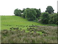
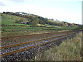
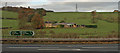
Pastures and woodland near Blenkinsop Castle
Image: © Mike Quinn
Taken: 21 Jun 2010
0.16 miles