IMAGES TAKEN NEAR TO
Greenhead, BRAMPTON, CA8 7JF
Introduction
This page details the photographs taken nearby to CA8 7JF by members of the Geograph project.
The Geograph project started in 2005 with the aim of publishing, organising and preserving representative images for every square kilometre of Great Britain, Ireland and the Isle of Man.

There are currently over 7.5m images from over14,400 individuals and you can help contribute to the project by visiting https://www.geograph.org.uk
Image Map
Images are licensed for reuse under creativecommons.org/licenses/by-sa/2.0
Notes
- Clicking on the map will re-center to the selected point.
- The higher the marker number, the further away the image location is from the centre of the postcode.
Image Listing (32 Images Found)
Images are licensed for reuse under creativecommons.org/licenses/by-sa/2.0
Image
Details
Distance
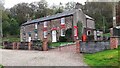
2
Byron Cottages with Byron Terrace behind
Image: © Roger Templeman
Taken: 10 May 2023
0.00 miles
3
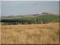
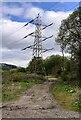
Blenkinsop Common west of Bankfoot
Looking ENE towards Image photographed by Dave Stamp.
Image: © Mike Quinn
Taken: 28 Oct 2011
0.06 miles
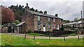
6
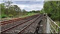
Railway line towards Haltwhistle from Blenkinsop Crossing
Image: © Luke Shaw
Taken: 10 May 2023
0.11 miles
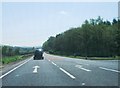
7
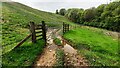
Gateway for track into field on SW side of A69
Image: © Roger Templeman
Taken: 10 May 2023
0.13 miles
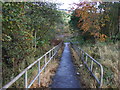
9
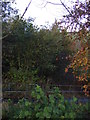
Path and woodland off the A69 near Greenhead
Image: © JThomas
Taken: 3 Nov 2012
0.14 miles
10
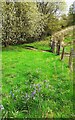
Patch of bluebells beside field fence for field on SW side of A69
Image: © Luke Shaw
Taken: 10 May 2023
0.14 miles