IMAGES TAKEN NEAR TO
Greenhead, BRAMPTON, CA8 7JD
Introduction
This page details the photographs taken nearby to CA8 7JD by members of the Geograph project.
The Geograph project started in 2005 with the aim of publishing, organising and preserving representative images for every square kilometre of Great Britain, Ireland and the Isle of Man.

There are currently over 7.5m images from over14,400 individuals and you can help contribute to the project by visiting https://www.geograph.org.uk
Image Map
Images are licensed for reuse under creativecommons.org/licenses/by-sa/2.0
Notes
- Clicking on the map will re-center to the selected point.
- The higher the marker number, the further away the image location is from the centre of the postcode.
Image Listing (82 Images Found)
Images are licensed for reuse under creativecommons.org/licenses/by-sa/2.0
Image
Details
Distance
1
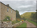
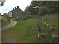
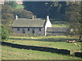
Walltown Farm
Solidly-built farmhouse immediately south of Hadrian's Wall, which runs along the crest of the ridge beyond.
Image: © Karl and Ali
Taken: 3 Aug 2015
0.00 miles
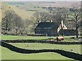
4
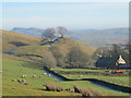
Walltown Farm
OK call us wimps, but from here we took the easy option and walked to Twice brewed on the low level route.
Image: © Ian S
Taken: 3 Apr 2012
0.01 miles
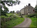
5
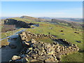
Turret 45a (Walltown) and Hadrian's Wall west of Walltown Farm
The turret lies on the west side of the Image, about 100 yards short (ie east) of the normal measured position. It was built as a free-standing tower before the Narrow Wall, 7ft 4in wide above the offset, was brought up to its east and west sides. The tower measures about 19 ft by 18ft externally, with its foundations resting on bedrock up to four courses deep depending upon the uneven nature of the rock surface. The door was probably in the southeast corner. The foundations, examined in 1959, contained a fragment of a pot of Hadrianic date. It is possible that the structure was built early in Hadrian's reign as a look-out for the troops on the Stanegate, probably at Image, to be subsumed within the Wall built a little later. Pottery indicated occupation in the second century only. {Source: "Handbook to the Roman Wall" (14th Edition) by J Collingwood Bruce.}
Image: © Mike Quinn
Taken: 28 Jan 2012
0.01 miles
6
Overgrown water trough, Walltown Farm
The large squared blocks of sandstone look like they may have once been part of Hadrian's Wall.
Image: © Karl and Ali
Taken: 3 Aug 2015
0.03 miles
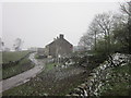
7
Walltown Farm
A similar view taken in October (2007) with the leaves still on the trees is shown in Image
Image: © Mike Quinn
Taken: 28 Jan 2012
0.03 miles
10
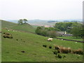
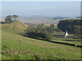
Walltown from Walltown Crags
Seen from the Hadrian's Wall Path.
Image: © David Purchase
Taken: 28 May 2013
0.04 miles