IMAGES TAKEN NEAR TO
Greenhead, BRAMPTON, CA8 7JB
Introduction
This page details the photographs taken nearby to CA8 7JB by members of the Geograph project.
The Geograph project started in 2005 with the aim of publishing, organising and preserving representative images for every square kilometre of Great Britain, Ireland and the Isle of Man.

There are currently over 7.5m images from over14,400 individuals and you can help contribute to the project by visiting https://www.geograph.org.uk
Image Map
Images are licensed for reuse under creativecommons.org/licenses/by-sa/2.0
Notes
- Clicking on the map will re-center to the selected point.
- The higher the marker number, the further away the image location is from the centre of the postcode.
Image Listing (12 Images Found)
Images are licensed for reuse under creativecommons.org/licenses/by-sa/2.0
Image
Details
Distance
1
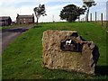
High Old Shields Farm
Northumbrian sheep farm, north of Hadrian's Wall
Image: © Bill Cresswell
Taken: 10 Sep 2006
0.01 miles
2
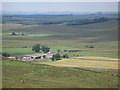
Moorland and pastures around High Old Shields Farm
Photo taken from Hadrian's Wall in Image
Image: © Mike Quinn
Taken: 10 Jul 2009
0.01 miles
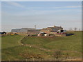
4
High Old Shields Farm
Looking north-west towards High Old Shields Farm, near Thirlwall Castle
Image: © Ian Drummond
Taken: 16 Oct 2005
0.02 miles
6
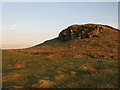
Collar Heugh Crag
Climbers refer to this sandstone outcrop as The Tipalt.
Image: © Karl and Ali
Taken: 5 Sep 2011
0.14 miles
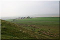
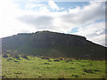
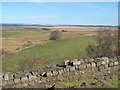
7
Farmland and moorland north of Hadrian's Wall
Image: © Mike Quinn
Taken: 11 Mar 2014
0.15 miles
8

Moorland north of Hadrian' Wall near Walltown (2)
Looking northwest towards Image
Image: © Mike Quinn
Taken: 10 Jul 2009
0.15 miles
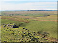
9
Rough grassland near Walltown
Looking towards the Whin Sill ridge of Hadrian's Wall.
Image: © Karl and Ali
Taken: 5 Sep 2011
0.21 miles
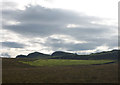
10
Rough pastures north of Hadrian's Wall
The buildings in the distance (left) are those at Image
Image: © Mike Quinn
Taken: 11 Mar 2014
0.21 miles