IMAGES TAKEN NEAR TO
Thirlwall View, BRAMPTON, CA8 7HL
Introduction
This page details the photographs taken nearby to Thirlwall View, CA8 7HL by members of the Geograph project.
The Geograph project started in 2005 with the aim of publishing, organising and preserving representative images for every square kilometre of Great Britain, Ireland and the Isle of Man.

There are currently over 7.5m images from over14,400 individuals and you can help contribute to the project by visiting https://www.geograph.org.uk
Image Map
Images are licensed for reuse under creativecommons.org/licenses/by-sa/2.0
Notes
- Clicking on the map will re-center to the selected point.
- The higher the marker number, the further away the image location is from the centre of the postcode.
Image Listing (132 Images Found)
Images are licensed for reuse under creativecommons.org/licenses/by-sa/2.0
Image
Details
Distance
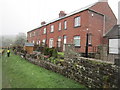
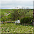
3
From the Pennine Way above Thirlwall
The terraced houses beside the railway line are called Thirlwall View. The ruin of Thirlwall Castle can be seen to the left together with Thirlwall Castle Farm above the wooded valley of Tipalt Burn.
Image: © Andrew Curtis
Taken: 25 Sep 2015
0.01 miles
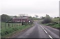
4
Junction of National Trails
At this point a short way north of Greenhead, the two arguably most popular National Trails - the oldest, the Pennine Way which runs 268 miles from Edale to Kirk Yetholm http://www.nationaltrail.co.uk/PennineWay/ and the newest, Hadrian's Wall Path Hadrians Wall National Trail which runs 84 miles from Bowness-on-Solway to Wallsend
http://www.nationaltrail.co.uk/hadrianswall/ - join forces and continue eastwards together over the finest section of Hadrian's Wall for some 12 Km.
Image: © Oliver Dixon
Taken: 27 Sep 2008
0.01 miles
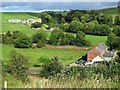
6
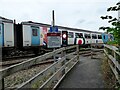
Train crossing the Hadrian's Wall National Trail
Image: © Sandy Gerrard
Taken: 14 Sep 2021
0.02 miles
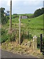
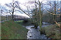
7
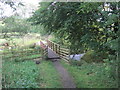
Footbridge and Footpath over Pow Charney Burn
Image: © Les Hull
Taken: 28 Aug 2012
0.03 miles
8
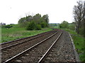
The Newcastle to Carlisle railway at Greenhead
The Hadrian's Wall Path, and also the Pennine Way, cross the railway here at 'ground level'. With a bend as close as this, the injunction "Stop. Look. Listen." should certainly be heeded.
A similar point nearby where the Hadrian's Wall Path crosses the line is seen in Image
Image: © David Purchase
Taken: 29 May 2013
0.03 miles
10
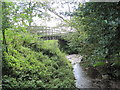
Footbridge and Confluence of Pow Charney Burn and Tipal Burn
Image: © Les Hull
Taken: 28 Aug 2012
0.04 miles