IMAGES TAKEN NEAR TO
Gilsland, BRAMPTON, CA8 7EH
Introduction
This page details the photographs taken nearby to CA8 7EH by members of the Geograph project.
The Geograph project started in 2005 with the aim of publishing, organising and preserving representative images for every square kilometre of Great Britain, Ireland and the Isle of Man.

There are currently over 7.5m images from over14,400 individuals and you can help contribute to the project by visiting https://www.geograph.org.uk
Image Map
Images are licensed for reuse under creativecommons.org/licenses/by-sa/2.0
Notes
- Clicking on the map will re-center to the selected point.
- The higher the marker number, the further away the image location is from the centre of the postcode.
Image Listing (25 Images Found)
Images are licensed for reuse under creativecommons.org/licenses/by-sa/2.0
Image
Details
Distance
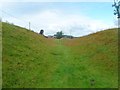
1
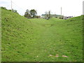
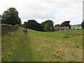
The Hadrian's Wall Path approaching "The Gap"
The Path is here following the north Ditch, but the Wall and Vallum were also very close by (on the left).
This apparently rather uninteresting spot is recorded for a specific reason. Within a few metres of here the Wall and the Path cross the main watershed of Great Britain. Everything behind the photographer flows into the North Sea (initially by the Tipal Burn and the River South Tyne). Everything in front flows into the Solway Firth and Irish Sea (initially by the River Irthing and the River Eden).
I have been unable to establish which way the small dip just ahead drains. Probably water collecting here just soaks into the ground.
Image: © David Purchase
Taken: 29 May 2013
0.01 miles
5
Hadrian's Wall Path between Chapel House Farm and Gilsland
Image: © Mike Quinn
Taken: 9 Sep 2009
0.05 miles
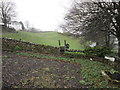
6
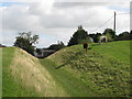
The north defensive ditch of Hadrian's Wall east of Gilsland (2)
Image: © Mike Quinn
Taken: 9 Sep 2009
0.06 miles
7
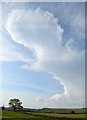
Hadrian's Wall Path at Gilsland 2
A disatant storm cloud viewed from the path between Gilsland and Holmhead.
Image: © Bobby Clegg
Taken: 18 Jun 2014
0.07 miles
8
The north defensive ditch of Hadrian's Wall east of Gilsland (3)
Image: © Mike Quinn
Taken: 9 Sep 2009
0.08 miles
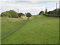
9
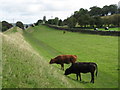
Cattle grazing in the north defensive ditch of Hadrian's Wall east of Gilsland
Image: © Mike Quinn
Taken: 9 Sep 2009
0.13 miles
10
In Hadrian's Wall Defence Ditch - Gilsland
Image: © Anthony Parkes
Taken: 4 Aug 2014
0.13 miles