IMAGES TAKEN NEAR TO
Gilsland, BRAMPTON, CA8 7AF
Introduction
This page details the photographs taken nearby to CA8 7AF by members of the Geograph project.
The Geograph project started in 2005 with the aim of publishing, organising and preserving representative images for every square kilometre of Great Britain, Ireland and the Isle of Man.

There are currently over 7.5m images from over14,400 individuals and you can help contribute to the project by visiting https://www.geograph.org.uk
Image Map
Images are licensed for reuse under creativecommons.org/licenses/by-sa/2.0
Notes
- Clicking on the map will re-center to the selected point.
- The higher the marker number, the further away the image location is from the centre of the postcode.
Image Listing (6 Images Found)
Images are licensed for reuse under creativecommons.org/licenses/by-sa/2.0
Image
Details
Distance
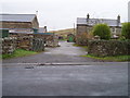
1

Bush Nook
Bush Nook seen from the A69.
Image: © Peter McDermott
Taken: 18 Dec 2011
0.01 miles

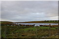
3
The Poltross burn
The Poltross burn forms the boundary between the former counties of Cumberland on the far bank, and Northumberland.
Image: © AlastairG
Taken: 26 Apr 2012
0.18 miles
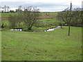
4
Shawfield Farm
Public Footpath through Shawfield Farm
Image: © Tim Fish
Taken: 22 Nov 2006
0.22 miles
5
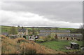
Shawfield farm, Cumbria
No longer a working farm, Shawfield was split since it was considered too small to be economically viable, in spite of having provided a living for a family until the tenant retired.
Image: © AlastairG
Taken: 26 Apr 2012
0.23 miles