IMAGES TAKEN NEAR TO
Crossgates Road, BRAMPTON, CA8 2PQ
Introduction
This page details the photographs taken nearby to Crossgates Road, CA8 2PQ by members of the Geograph project.
The Geograph project started in 2005 with the aim of publishing, organising and preserving representative images for every square kilometre of Great Britain, Ireland and the Isle of Man.

There are currently over 7.5m images from over14,400 individuals and you can help contribute to the project by visiting https://www.geograph.org.uk
Image Map
Images are licensed for reuse under creativecommons.org/licenses/by-sa/2.0
Notes
- Clicking on the map will re-center to the selected point.
- The higher the marker number, the further away the image location is from the centre of the postcode.
Image Listing (16 Images Found)
Images are licensed for reuse under creativecommons.org/licenses/by-sa/2.0
Image
Details
Distance
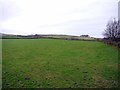
1
Sink hole by Crossgates Road
Shows that limestone rock lies not far below the surface. Park Terrace can be seen in the distance.
Image: © Andrew Curtis
Taken: 6 Jan 2012
0.04 miles
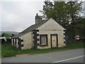
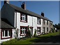
4
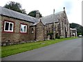
Old Wesleyan Chapel, Hallbankgate
Now converted to residential use.
Image: © Oliver Dixon
Taken: 7 Aug 2020
0.12 miles
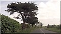
5
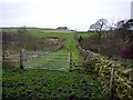
Lane near Clement Leazes
The footpath, invisible on the ground and little signed makes a sharp left turn before the gate
Image: © Andrew Curtis
Taken: 6 Jan 2012
0.13 miles
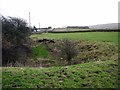
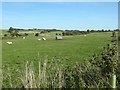
7
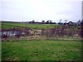
Pond and woodland south-east of Clement Leazes
Clement Leazes farm can be seen on the right.
Image: © Andrew Curtis
Taken: 6 Jan 2012
0.17 miles