IMAGES TAKEN NEAR TO
Low Row, BRAMPTON, CA8 2LE
Introduction
This page details the photographs taken nearby to CA8 2LE by members of the Geograph project.
The Geograph project started in 2005 with the aim of publishing, organising and preserving representative images for every square kilometre of Great Britain, Ireland and the Isle of Man.

There are currently over 7.5m images from over14,400 individuals and you can help contribute to the project by visiting https://www.geograph.org.uk
Image Map
Images are licensed for reuse under creativecommons.org/licenses/by-sa/2.0
Notes
- Clicking on the map will re-center to the selected point.
- The higher the marker number, the further away the image location is from the centre of the postcode.
Image Listing (49 Images Found)
Images are licensed for reuse under creativecommons.org/licenses/by-sa/2.0
Image
Details
Distance
1
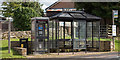
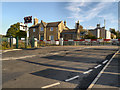
Low Row village - September 2016 (1)
The bus stop, shelter and telephone box.
Image: © The Carlisle Kid
Taken: 11 Sep 2016
0.02 miles
2
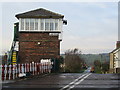
Low Row level crossing and signalbox
A wider view of the crossing shown in Image
In summer 2009 the signalbox was taken out of use and demolished, being replaced by a new one nearby, and the crossing converted to automatic operation Image [source: Modern Railways magazine, August 2009]
Another contributor pointed out that the 'gates' at the time of the photo were the less common 'Boom Gates'; an electric motor on each gate powered a tyred wheel to drive the gate open or closed.
Image: © Stephen Craven
Taken: 18 May 2007
0.02 miles
3
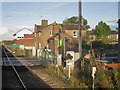
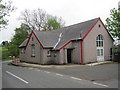
Low Row railway station (site), Cumbria
Opened in 1836 by the Newcastle and Carlisle Railway, later part of the North Eastern Railway, this station closed in 1959.
View north east from a passing train towards Gilsland and Newcastle.
Image: © Nigel Thompson
Taken: 11 Oct 2014
0.04 miles
4
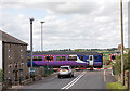
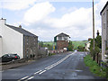
Low Row village - September 2016 (2)
Low Row level crossing - on the Carlisle to Newcastle line. The train is the 14.10 passenger service from Carlisle to Newcastle.
Image: © The Carlisle Kid
Taken: 11 Sep 2016
0.04 miles
5
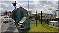
Site of demolished Low Row signal box
Ordnance Survey documents indicate that a benchmark levelled at 140.617m above Newlyn Datum was verified in 1955 on the signal box previously at this location
Image: © Roger Templeman
Taken: 26 Apr 2023
0.04 miles
8
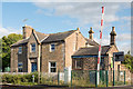
Former Low Row station - September 2016
Dating from 1836, Low Row station was closed in 1959. A 2014 view may be seen: Image] .
Image: © The Carlisle Kid
Taken: 16 Sep 2016
0.04 miles