IMAGES TAKEN NEAR TO
Walton, BRAMPTON, CA8 2JP
Introduction
This page details the photographs taken nearby to CA8 2JP by members of the Geograph project.
The Geograph project started in 2005 with the aim of publishing, organising and preserving representative images for every square kilometre of Great Britain, Ireland and the Isle of Man.

There are currently over 7.5m images from over14,400 individuals and you can help contribute to the project by visiting https://www.geograph.org.uk
Image Map
Images are licensed for reuse under creativecommons.org/licenses/by-sa/2.0
Notes
- Clicking on the map will re-center to the selected point.
- The higher the marker number, the further away the image location is from the centre of the postcode.
Image Listing (13 Images Found)
Images are licensed for reuse under creativecommons.org/licenses/by-sa/2.0
Image
Details
Distance
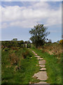
1
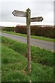
Hadrian's Wall Path sign near Garthside
On the western side of the road from Burtholme to Garthside.
Image: © Dave Dunford
Taken: 10 May 2013
0.10 miles
7
Hadrian's Wall unrestored
A rather dilapidated section of Hadrian's Wall just west of the site of Turret 54A.
Image: © Dave Dunford
Taken: 10 May 2013
0.16 miles
8
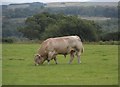
I'm glad this big beast wasn't directly in my way!
Image: © Anthony Parkes
Taken: 4 Aug 2014
0.16 miles