IMAGES TAKEN NEAR TO
Low Row, BRAMPTON, CA8 2JB
Introduction
This page details the photographs taken nearby to CA8 2JB by members of the Geograph project.
The Geograph project started in 2005 with the aim of publishing, organising and preserving representative images for every square kilometre of Great Britain, Ireland and the Isle of Man.

There are currently over 7.5m images from over14,400 individuals and you can help contribute to the project by visiting https://www.geograph.org.uk
Image Map
Images are licensed for reuse under creativecommons.org/licenses/by-sa/2.0
Notes
- Clicking on the map will re-center to the selected point.
- The higher the marker number, the further away the image location is from the centre of the postcode.
Image Listing (20 Images Found)
Images are licensed for reuse under creativecommons.org/licenses/by-sa/2.0
Image
Details
Distance
1
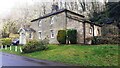
Craig Cottage on south side of minor road east of Low Houses
A porch has been added on the far corner of the house since the 2010 Geograph Image Ordnance Survey documents indicate that a benchmark levelled at 185.157m above Newlyn Datum was verified in 1955 on that corner of the house
Image: © Roger Templeman
Taken: 24 Mar 2023
0.00 miles

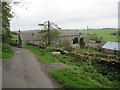
3

Barn with hay bales on north side of road opposite Craig Cottage
Image: © Roger Templeman
Taken: 24 Mar 2023
0.03 miles
4

Sheep in pasture beside the A69
Low Houses in the trees beyond.
Image: © Russel Wills
Taken: 1 Jun 2017
0.08 miles


10

Wall with field gate on north side of minor road east of Highfield
Image: © Roger Templeman
Taken: 24 Mar 2023
0.13 miles