IMAGES TAKEN NEAR TO
BRAMPTON, CA8 2HA
Introduction
This page details the photographs taken nearby to CA8 2HA by members of the Geograph project.
The Geograph project started in 2005 with the aim of publishing, organising and preserving representative images for every square kilometre of Great Britain, Ireland and the Isle of Man.

There are currently over 7.5m images from over14,400 individuals and you can help contribute to the project by visiting https://www.geograph.org.uk
Image Map
Images are licensed for reuse under creativecommons.org/licenses/by-sa/2.0
Notes
- Clicking on the map will re-center to the selected point.
- The higher the marker number, the further away the image location is from the centre of the postcode.
Image Listing (13 Images Found)
Images are licensed for reuse under creativecommons.org/licenses/by-sa/2.0
Image
Details
Distance
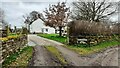
1
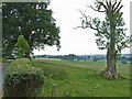
View from High Boothby, near Lanercost
Great Easby can be seen in the distance
Image: © Oliver Dixon
Taken: 20 Jul 2006
0.01 miles
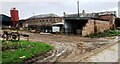
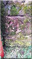
3
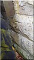
Benchmark on barn at Easby Farm
Ordnance Survey cut mark benchmark levelled at 68.422m above Newlyn Datum verified 1955
Image: © Roger Templeman
Taken: 1 Apr 2023
0.03 miles
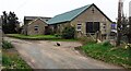
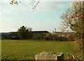
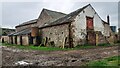
4
Former milking parlour at Easby Farm
There is an Ordnance Survey benchmark Image about 5 feet right from the near corner of the building behind a pile of fence posts
Image: © Roger Templeman
Taken: 1 Apr 2023
0.04 miles
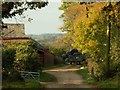
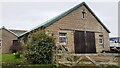
9
Buildings at Great Easby Farm
There is an Ordnance Survey benchmark Image on the near corner, left hand face, of the nearest building which has a sagging roof and is due for demolition, which will mean loss of the benchmark.
Image: © Roger Templeman
Taken: 1 Apr 2023
0.08 miles
10
Benchmark on barn at Great Easby Farm
Mossy Ordnance Survey cut mark benchmark levelled at 66.297m above Newlyn Datum verified 1955
Image: © Roger Templeman
Taken: 1 Apr 2023
0.09 miles