IMAGES TAKEN NEAR TO
Easby Lane End, BRAMPTON, CA8 2EZ
Introduction
This page details the photographs taken nearby to Easby Lane End, CA8 2EZ by members of the Geograph project.
The Geograph project started in 2005 with the aim of publishing, organising and preserving representative images for every square kilometre of Great Britain, Ireland and the Isle of Man.

There are currently over 7.5m images from over14,400 individuals and you can help contribute to the project by visiting https://www.geograph.org.uk
Image Map
Images are licensed for reuse under creativecommons.org/licenses/by-sa/2.0
Notes
- Clicking on the map will re-center to the selected point.
- The higher the marker number, the further away the image location is from the centre of the postcode.
Image Listing (9 Images Found)
Images are licensed for reuse under creativecommons.org/licenses/by-sa/2.0
Image
Details
Distance
1

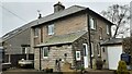
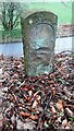
Benchmark on West Cottage
A planter has been placed in front of the Ordnance Survey cut mark benchmark so that only its horizontal datum cut is visible. The mark was levelled at 101.922m above Newlyn Datum verified 1955
Image: © Roger Templeman
Taken: 1 Apr 2023
0.00 miles
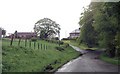
2
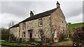
West Cottage on east side of road to Easby
There is an Ordnance Survey benchmark Image on the near corner of the extension behind a planter
Image: © Roger Templeman
Taken: 1 Apr 2023
0.01 miles
4
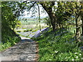
Bluebells near Boothby
Seen on the lane to Great Easby.
Image: © David Purchase
Taken: 13 May 2019
0.06 miles

6
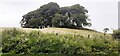
Clump of trees on small hill on west side of The Swartle
Image: © Roger Templeman
Taken: 11 Jul 2022
0.09 miles
7
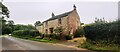
Ridgefoot on west side of road opposite The Keep Wood
The Ordnance Survey 1883-1913 6" Map shows a benchmark levelled at 319.3 feet above Liverpool Datum on the near corner of the house where there is a stone gatepost
Image: © Roger Templeman
Taken: 1 Apr 2023
0.16 miles
8
Ridgefoot on NW side of The Swarttle
Image: © Roger Templeman
Taken: 11 Jul 2022
0.17 miles
9
Stone post with inscription in small wood opposite The Keep
There are similar posts nearby: Image and Image Perhaps they mark a boundary? This stone has Milestone Society National ID: CU_BRAMP03bm
Image: © Roger Templeman
Taken: 29 Mar 2023
0.25 miles