IMAGES TAKEN NEAR TO
West Hall, BRAMPTON, CA8 2ET
Introduction
This page details the photographs taken nearby to CA8 2ET by members of the Geograph project.
The Geograph project started in 2005 with the aim of publishing, organising and preserving representative images for every square kilometre of Great Britain, Ireland and the Isle of Man.

There are currently over 7.5m images from over14,400 individuals and you can help contribute to the project by visiting https://www.geograph.org.uk
Image Map (Loading...)


Getting Data...Please wait
Leaflet Map data © OpenStreetMap
Images are licensed for reuse under creativecommons.org/licenses/by-sa/2.0
Notes
- Clicking on the map will re-center to the selected point.
- The higher the marker number, the further away the image location is from the centre of the postcode.
Image Listing (4 Images Found)
Images are licensed for reuse under creativecommons.org/licenses/by-sa/2.0
Image
Details
Distance
1
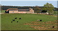
Palmer Hill
Palmer Hill Farm near Spadeadam.
Image: © Peter McDermott
Taken: 2 May 2009
0.00 miles
2
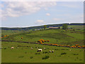
Palmer Hill
Looking across to the farm, which is on the western edge of the grid-square, from the road to Spadeadam Farm. The gorse is in the valley of an unnamed King Water tributary.
Image: © John Hill
Taken: 26 May 2008
0.06 miles
3
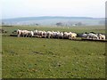
Sheep feeding near Palmer Hill
Waterhead Common (part of Spadeadam Forest) Image can be seen on the skyline beyond the valley of the King Water.
Image: © Oliver Dixon
Taken: 20 Dec 2007
0.15 miles
4
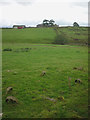
'Rust in peace', Palmer Hill
Four small iron wheels are all that remain of a small agricultural cart or trolley by the footpath that leads round the edge of the pasture. Palmer Hill is on the skyline ahead.
Image: © Karl and Ali
Taken: 6 Sep 2016
0.17 miles