IMAGES TAKEN NEAR TO
West Hall, BRAMPTON, CA8 2EL
Introduction
This page details the photographs taken nearby to CA8 2EL by members of the Geograph project.
The Geograph project started in 2005 with the aim of publishing, organising and preserving representative images for every square kilometre of Great Britain, Ireland and the Isle of Man.

There are currently over 7.5m images from over14,400 individuals and you can help contribute to the project by visiting https://www.geograph.org.uk
Image Map
Images are licensed for reuse under creativecommons.org/licenses/by-sa/2.0
Notes
- Clicking on the map will re-center to the selected point.
- The higher the marker number, the further away the image location is from the centre of the postcode.
Image Listing (4 Images Found)
Images are licensed for reuse under creativecommons.org/licenses/by-sa/2.0
Image
Details
Distance
2
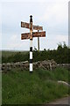
Road Sign at Lees Hill
Road sign at the crossroads at Quarry Lodge near Lees Hill.
Image: © Peter McDermott
Taken: 9 Jun 2007
0.03 miles
3
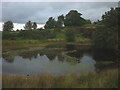
Pond at Lees Hill Quarry
A small sandstone quarry now overgrown and flooded.
Image: © Karl and Ali
Taken: 6 Sep 2016
0.13 miles
4
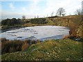
Lees Hill Quarry
Obviously long-abandoned. The pond in the valley floor is frozen hard on a frosty December day.
Image: © Oliver Dixon
Taken: 20 Dec 2007
0.15 miles