IMAGES TAKEN NEAR TO
Walton, BRAMPTON, CA8 2EA
Introduction
This page details the photographs taken nearby to CA8 2EA by members of the Geograph project.
The Geograph project started in 2005 with the aim of publishing, organising and preserving representative images for every square kilometre of Great Britain, Ireland and the Isle of Man.

There are currently over 7.5m images from over14,400 individuals and you can help contribute to the project by visiting https://www.geograph.org.uk
Image Map
Images are licensed for reuse under creativecommons.org/licenses/by-sa/2.0
Notes
- Clicking on the map will re-center to the selected point.
- The higher the marker number, the further away the image location is from the centre of the postcode.
Image Listing (7 Images Found)
Images are licensed for reuse under creativecommons.org/licenses/by-sa/2.0
Image
Details
Distance
2
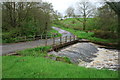
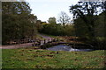
Ford at Solmain
This irish bridge ford is found on the Pristol Beck at Solmain.
Image: © John Walton
Taken: 10 May 2014
0.11 miles
5
Old bridge with flood debris blocking behind it
Image: © David Liddle
Taken: 16 Oct 2008
0.13 miles
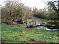
6
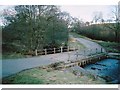
Irish bridge, Solmain
This Irish bridge (culverted ford) takes the road over Cam Beck.
Image: © Andrew Smith
Taken: Unknown
0.18 miles
7
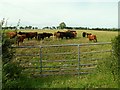
Public footpath?
The map shows a footpath starting from here, going diagonally across the field to Solmain Farm. However, there was no signpost or worn track, and we didn't fancy disturbing these chaps.
Image: © Rose and Trev Clough
Taken: 13 Jul 2008
0.18 miles