IMAGES TAKEN NEAR TO
Tree Road, BRAMPTON, CA8 1TX
Introduction
This page details the photographs taken nearby to Tree Road, CA8 1TX by members of the Geograph project.
The Geograph project started in 2005 with the aim of publishing, organising and preserving representative images for every square kilometre of Great Britain, Ireland and the Isle of Man.

There are currently over 7.5m images from over14,400 individuals and you can help contribute to the project by visiting https://www.geograph.org.uk
Image Map
Images are licensed for reuse under creativecommons.org/licenses/by-sa/2.0
Notes
- Clicking on the map will re-center to the selected point.
- The higher the marker number, the further away the image location is from the centre of the postcode.
Image Listing (64 Images Found)
Images are licensed for reuse under creativecommons.org/licenses/by-sa/2.0
Image
Details
Distance
1
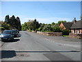
Tree Road, Brampton
Basically a residential area, but with a small hospital ahead on the left.
Image: © David Purchase
Taken: 13 May 2019
0.02 miles
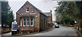
2
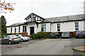
Brampton War Memorial Hospital
The hospital opened in 1923. It was built to commemorate those from Brampton and surrounding parishes who died for their country in World War I. Their names (144 in total) are recorded on wooden boards inside the building - for more information, see IWM war memorials register https://www.iwm.org.uk/memorials/item/memorial/4290 and Royal British Legion, Carlisle & Stanwix Branch http://branches.britishlegion.org.uk/branches/carlisle/ww1-heroes-walk-of-honour/memorial-18-brampton-hospital-war-memorial-brampton .
Still in use today, the hospital has 15 beds and provides various outpatient services.
See also Image .
Image: © Rose and Trev Clough
Taken: 24 Oct 2018
0.07 miles
3

Door, Brampton & District War Memorial Hospital
The hospital was opened in 1923. For a wider view of the building, see Image .
Sandstone blocks at the top of the steps are inscribed 'RHODA Countess of Carlisle' and 'GEORGE 11th Earl of Carlisle'. There are at least two more inscribed stones in the lower part of the brickwork, partially obscured by vegetation. Visible parts of the names were - ? W Chance J.P. - and ? A Allison J.P. .
Image: © Rose and Trev Clough
Taken: 24 Oct 2018
0.07 miles
5
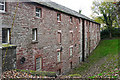
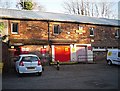
Back of the Old Brewery
The front of the building forms one end of a yard, as seen in this photo Image . The Old Brewery has been converted to several business units, opened in 1997.
This building looks quite old, possibly dating from when the brewery was established in 1785 - see Image .
Image: © Rose and Trev Clough
Taken: 24 Oct 2018
0.12 miles
6
Royal Mail Delivery Office, Brampton
Occupying part of the converted Old Brewery. For a wider view of the site, see Image .
Image: © Rose and Trev Clough
Taken: 23 Nov 2016
0.14 miles
7
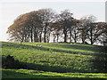
Farmland and copse southeast of Millfield
Image: © Mike Quinn
Taken: 14 Nov 2013
0.16 miles
9
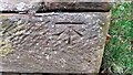
Benchmark on bottom quoin of house at Hemblesgate
Ordnance Survey cut mark benchmark levelled at 88.358m above Newlyn Datum verified 1972
Image: © Roger Templeman
Taken: 21 Mar 2023
0.17 miles
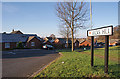
10
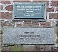
Plaques on the Old Brewery, Brampton
With help from the Rural Development Commission the Old Brewery Buildings were saved and are still in use. Was the brewery called the 'Old Brewery' in 1785?
Image: © Humphrey Bolton
Taken: 29 Jan 2009
0.17 miles