IMAGES TAKEN NEAR TO
Oak Park, BRAMPTON, CA8 1TP
Introduction
This page details the photographs taken nearby to Oak Park, CA8 1TP by members of the Geograph project.
The Geograph project started in 2005 with the aim of publishing, organising and preserving representative images for every square kilometre of Great Britain, Ireland and the Isle of Man.

There are currently over 7.5m images from over14,400 individuals and you can help contribute to the project by visiting https://www.geograph.org.uk
Image Map
Images are licensed for reuse under creativecommons.org/licenses/by-sa/2.0
Notes
- Clicking on the map will re-center to the selected point.
- The higher the marker number, the further away the image location is from the centre of the postcode.
Image Listing (81 Images Found)
Images are licensed for reuse under creativecommons.org/licenses/by-sa/2.0
Image
Details
Distance
2
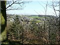
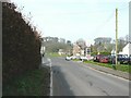
East-southeast view from The Motte, Brampton
Looking in the direction of Station Road with The Pennines in the distance.
Image: © John Baker
Taken: 26 Mar 2012
0.08 miles
3
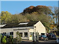
Garage on the site of the Staith, Brampton
The staith was at the end of the Brampton and Hartleyburn Railway, which was 2km long and connected to the main line at Brampton Junction station. This started as a colliery tramway, and the passenger service was by primitive carriages pulled by a horse until 1881, when the 0-4-0 'Dandie Dimont' locomotive was employed, cutting the journey time from 20 mins. to 3 mins. (Information from the notes on the Godfrey Edition reprint of the 1924 OS map of Brampton)
Image: © Humphrey Bolton
Taken: 27 Jan 2009
0.08 miles
4
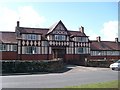
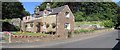
The Wilson Memorial Homes
Cottage homes, mainly for retired people, opened in 1930. Built by Isaac Wilson, a local man who became a wealthy builder in London.
Image: © Rose and Trev Clough
Taken: 9 Apr 2008
0.10 miles
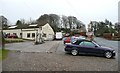
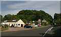
5
Station Road, Brampton
The Spot filling station was selling unleaded petrol at £144.9/litre and diesel at £149.9/litre. The garage is situated opposite Tree Road (whose entrance is marked by dotted white lines).
Image: © John Baker
Taken: 24 Mar 2012
0.10 miles
7
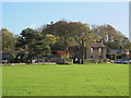
House on the Edge of Brampton
Beautiful garden
Image: © Les Hull
Taken: 12 Aug 2015
0.11 miles
8
Garage on the site of the former Brampton Town station
A wider view is shown in Image (photographed by Peter McDermott). The same view as the latter, but almost 50 years earlier in 1962, is shown in Image (photographed by Ben Brooksbank) in which the bridge over the road (in the distance, right) is still there.
Image: © Mike Quinn
Taken: 14 Nov 2013
0.11 miles
9
Site of Brampton Town Station
For an earlier view see Ben Brooksbank's picture from 1962 Image
Image: © Peter McDermott
Taken: 5 Jun 2010
0.11 miles
10
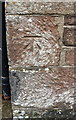
Benchmark on house 'Edgewood'
Ordnance Survey cut mark benchmark levelled at 90.905m above Newlyn Datum in 1971
Image: © Roger Templeman
Taken: 31 May 2019
0.11 miles