IMAGES TAKEN NEAR TO
Well Lonning Close, BRAMPTON, CA8 1TJ
Introduction
This page details the photographs taken nearby to Well Lonning Close, CA8 1TJ by members of the Geograph project.
The Geograph project started in 2005 with the aim of publishing, organising and preserving representative images for every square kilometre of Great Britain, Ireland and the Isle of Man.

There are currently over 7.5m images from over14,400 individuals and you can help contribute to the project by visiting https://www.geograph.org.uk
Image Map
Images are licensed for reuse under creativecommons.org/licenses/by-sa/2.0
Notes
- Clicking on the map will re-center to the selected point.
- The higher the marker number, the further away the image location is from the centre of the postcode.
Image Listing (134 Images Found)
Images are licensed for reuse under creativecommons.org/licenses/by-sa/2.0
Image
Details
Distance
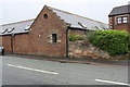
1
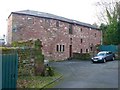
The New Brewery, Brampton
Now a house, but still retaining the look of an old industrial building.
Image: © Humphrey Bolton
Taken: 29 Jan 2009
0.10 miles
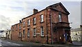
2
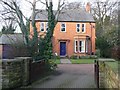
The Vicarage, Main Street, Brampton
There is former vicarage in Falkins Hill, which this house presumably replaced.
Image: © Humphrey Bolton
Taken: 29 Jan 2009
0.10 miles
3
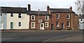
Row of houses on NW side of Carlisle Road opposite road junction
Ordnance Survey documents indicate that a benchmark was levelled on the front of a house here at 225.251 feet above Liverpool Datum in 1844 during the Carlisle to North Shields 1GL Survey. The surveyor's description was 'No. 33. Mark on front of house in Main-street, Brampton, at junction of roads ; 1.08 ft. above surface'
Image: © Roger Templeman
Taken: 15 Feb 2023
0.11 miles
4
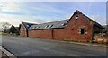
Townfoot Court on NW side of Carlisle Road
There is an Ordnance Survey benchmark Image on the right hand corner of the building just above pavement level
Image: © Roger Templeman
Taken: 15 Feb 2023
0.11 miles
5
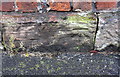
Benchmark on building at Townfoot Court, Carlisle Road
Ordnance Survey cut mark benchmark levelled at 69.296m above Newlyn Datum
Image: © Roger Templeman
Taken: 31 May 2019
0.11 miles
6
Townfoot Court building, Carlisle Road
There is an OS benchmark Image on the near corner of the building left of the black downpipe
Image: © Roger Templeman
Taken: 31 May 2019
0.11 miles
8
Police Station, formerly National School, at Carlisle Road / Longtown Road junction
Ordnance Survey documents indicate that a benchmark was levelled on the near corner of the building at 220.421 feet above Liverpool Datum in 1844 during the Carlisle to North Shields 1GL Survey. The surveyor's description was 'No. 34. Mark on South-east corner of Brampton National School-house ; 2.40 ft. above surface'
Image: © Roger Templeman
Taken: 15 Feb 2023
0.14 miles
9
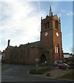
St Martin's Church, Front Street, Brampton
Rebuilt by Philip Webb for the Howards of Naworth, Earls of Carlisle, in 1874-8. An unconventual design using a mixture of styles. The west tower serves as a porch; it has a giant niche with a large window and below two very small two-light windows for the baptistery. The small lead spire has extensions to the north and south with pitched lead roofs. The prominent two-light north aisle windows are gabled and embattled, with the merlons climbing up and having sloping tops. The vestry has windows high up, over a bare wall, and a prominent chimney. The south aisle west window is round with tracery, and on the south side it has a pattern of alternating small rectangular windows and bare gabled stretches. The last window to the east is of three lights in Perpendicular-style. The roof slopes up from the aisle eaves to the nave ridge. The large five-light east window has flowing tracery. (Condensed from Pevsner's description)
Image: © Humphrey Bolton
Taken: 29 Jan 2009
0.14 miles
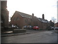
10
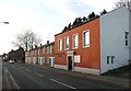
Bethesda Evangelical Church, Main Street, Brampton
Beyond it a row of cottages, perhaps built for workers at the New Brewery?
Image: © Humphrey Bolton
Taken: 29 Jan 2009
0.14 miles