IMAGES TAKEN NEAR TO
Paving Brow, BRAMPTON, CA8 1QS
Introduction
This page details the photographs taken nearby to Paving Brow, CA8 1QS by members of the Geograph project.
The Geograph project started in 2005 with the aim of publishing, organising and preserving representative images for every square kilometre of Great Britain, Ireland and the Isle of Man.

There are currently over 7.5m images from over14,400 individuals and you can help contribute to the project by visiting https://www.geograph.org.uk
Image Map
Images are licensed for reuse under creativecommons.org/licenses/by-sa/2.0
Notes
- Clicking on the map will re-center to the selected point.
- The higher the marker number, the further away the image location is from the centre of the postcode.
Image Listing (5 Images Found)
Images are licensed for reuse under creativecommons.org/licenses/by-sa/2.0
Image
Details
Distance
3
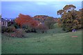
Twilight View Towards Brampton From Geld Road
Image: © Mick Garratt
Taken: 28 Oct 2008
0.19 miles
4
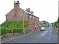
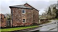
House at Hemblesgate on west side of Craw Hall
There is an Ordnance Survey benchmark Image on the corner (road face) of the left hand section of the house
Image: © Roger Templeman
Taken: 21 Mar 2023
0.24 miles
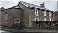
5
House at Hemblesgate on west side of B6413
Image: © Luke Shaw
Taken: 21 Mar 2023
0.24 miles