IMAGES TAKEN NEAR TO
Market Place, BRAMPTON, CA8 1NW
Introduction
This page details the photographs taken nearby to Market Place, CA8 1NW by members of the Geograph project.
The Geograph project started in 2005 with the aim of publishing, organising and preserving representative images for every square kilometre of Great Britain, Ireland and the Isle of Man.

There are currently over 7.5m images from over14,400 individuals and you can help contribute to the project by visiting https://www.geograph.org.uk
Image Map
Images are licensed for reuse under creativecommons.org/licenses/by-sa/2.0
Notes
- Clicking on the map will re-center to the selected point.
- The higher the marker number, the further away the image location is from the centre of the postcode.
Image Listing (245 Images Found)
Images are licensed for reuse under creativecommons.org/licenses/by-sa/2.0
Image
Details
Distance
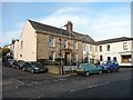
2
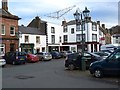
Front Street, Brampton
The red sandstone building on the right was built in 1883 for the Cumberland Union Banking Company and subsequently owned by the York City and County Bank, the London Joint Stock Bank, the Midland Bank and finally HSBC before ceasing to be a bank and becoming a retail food outlet.
At the end of the cobbles near the corner of the pavement beside the roadway there is an inset telephone cable junction marker (detail photograph Image).
Note the very small 'No Entry' sign.
Image: © Adrian Taylor
Taken: 31 Jul 2024
0.01 miles
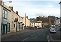
3
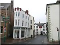
The southern end of High Cross Street, Brampton
This was even narrower before a building on the left was demolished some time after 1926, replaced by the present narrow tapering building. At the White Lion Hotel, which was established by 1790 although it might originally have been two houses, the street turns right and Beck Lane is to the left.
Image: © Humphrey Bolton
Taken: 27 Jan 2009
0.01 miles
4
Laurel House, Main Street, Brampton
A house of the 1830s-1840s, later a club. The porch is in Prostyle Ionic style.
Image: © Humphrey Bolton
Taken: 29 Jan 2009
0.01 miles
5
Main Street, Brampton
Laurel House is behind the CCTV 'spy' camera, and the Methodist Church is in the distance, where the road swings to the right.
Image: © Humphrey Bolton
Taken: 29 Jan 2009
0.01 miles
6
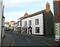
High Cross Street, Brampton
The side of the White Lion is on the left, and the building in the centre of the view is known as Charlie's House. It was built in the late 17C, and altered in the 18C and 19C. The plaque reads "In 1745 Bonnie Prince Charlie established his headquarters here during the siege of Carlisle from November 12th to 18th 1745". Whether this was at the invitation of the owner of the house is not recorded.
Image: © Humphrey Bolton
Taken: 29 Jan 2009
0.01 miles
7
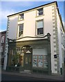
No 2 High Cross Street, Brampton
This was built in the early 19C as a house, and converted to a shop in the late 19C, from which time it retains its fine shop front. The street name plate is in the shop window, having apparently fallen from the right corner of the building.
Image: © Humphrey Bolton
Taken: 29 Jan 2009
0.01 miles
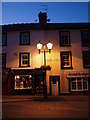
8
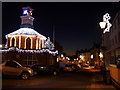
Tourist Information Office and Brampton at Christmas
Image: © Sharon Leedell
Taken: 9 Dec 2008
0.01 miles
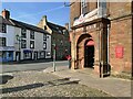
9
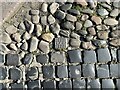
G.P.O. Cable Junction Marker
Installed sometime prior to October 1969, this small General Post Office marker between whinstone setts and cobbles in Front Street, Brampton, indicates the location of an underground telephone cable junction. These markers were used to help telephone engineers locate cables when they needed to carry out repairs or maintenance.
Image: © Adrian Taylor
Taken: 31 Jul 2024
0.01 miles