IMAGES TAKEN NEAR TO
Talkin, BRAMPTON, CA8 1LR
Introduction
This page details the photographs taken nearby to CA8 1LR by members of the Geograph project.
The Geograph project started in 2005 with the aim of publishing, organising and preserving representative images for every square kilometre of Great Britain, Ireland and the Isle of Man.

There are currently over 7.5m images from over14,400 individuals and you can help contribute to the project by visiting https://www.geograph.org.uk
Image Map (Loading...)


Getting Data...Please wait
Leaflet Map data © OpenStreetMap
Images are licensed for reuse under creativecommons.org/licenses/by-sa/2.0
Notes
- Clicking on the map will re-center to the selected point.
- The higher the marker number, the further away the image location is from the centre of the postcode.
Image Listing (11 Images Found)
Images are licensed for reuse under creativecommons.org/licenses/by-sa/2.0
Image
Details
Distance
1
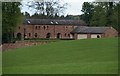
Netherton
Converted barns at Netherton Farm.
Image: © Peter McDermott
Taken: 2 May 2009
0.05 miles
2

Interior of Talkin Church, Talkin, Brampton
Image: © Alexander P Kapp
Taken: 30 Apr 2006
0.14 miles
7
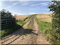
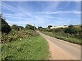
Farm track
Off the Talkin to Hayton road.
Image: © Richard Webb
Taken: 31 Aug 2024
0.22 miles
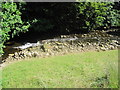
9
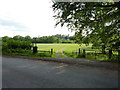
Meadow by the River Gelt
Gelt Mill can be seen in the trees.
Image: © Oliver Dixon
Taken: 7 Aug 2020
0.23 miles
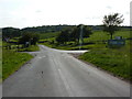
10
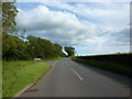
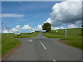
Junction on the B6413
The road to the left, goes to Talkin
Image: © Alexander P Kapp
Taken: 16 Jun 2011
0.23 miles