IMAGES TAKEN NEAR TO
Stanley Road, BRAMPTON, CA8 1DX
Introduction
This page details the photographs taken nearby to Stanley Road, CA8 1DX by members of the Geograph project.
The Geograph project started in 2005 with the aim of publishing, organising and preserving representative images for every square kilometre of Great Britain, Ireland and the Isle of Man.

There are currently over 7.5m images from over14,400 individuals and you can help contribute to the project by visiting https://www.geograph.org.uk
Image Map
Images are licensed for reuse under creativecommons.org/licenses/by-sa/2.0
Notes
- Clicking on the map will re-center to the selected point.
- The higher the marker number, the further away the image location is from the centre of the postcode.
Image Listing (5 Images Found)
Images are licensed for reuse under creativecommons.org/licenses/by-sa/2.0
Image
Details
Distance
1
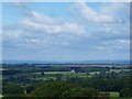
View NorthWest from the Ridge, Brampton
A truly amazing view in all directions can be seen from the Ridge on a clear day.
Image: © Sharon Leedell
Taken: 21 Jun 2009
0.20 miles
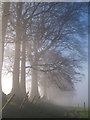
2
Farmland and woodland north of Brampton Ridge
Photo taken from the lower northern slopes of The Motte.
Image: © Mike Quinn
Taken: 14 Nov 2013
0.20 miles
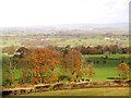
3
Brampton Ridge
The cloud ebbed and flowed and allowed me to capture this wonderful scene along the edge. Moments later the view was lost in thick fog!
Image: © Sharon Leedell
Taken: 6 Nov 2011
0.21 miles
4
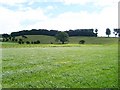
Fields below Brampton Ridge
The Ridge is a long mound of debris left behind from the glacial period.
Image: © Rose and Trev Clough
Taken: 16 Jul 2008
0.24 miles
5
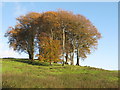
Copse on Brampton Ridge
The copse can also be seen in Image
Image: © Mike Quinn
Taken: 14 Nov 2013
0.24 miles