IMAGES TAKEN NEAR TO
Longtown Road, BRAMPTON, CA8 1AN
Introduction
This page details the photographs taken nearby to Longtown Road, CA8 1AN by members of the Geograph project.
The Geograph project started in 2005 with the aim of publishing, organising and preserving representative images for every square kilometre of Great Britain, Ireland and the Isle of Man.

There are currently over 7.5m images from over14,400 individuals and you can help contribute to the project by visiting https://www.geograph.org.uk
Image Map
Images are licensed for reuse under creativecommons.org/licenses/by-sa/2.0
Notes
- Clicking on the map will re-center to the selected point.
- The higher the marker number, the further away the image location is from the centre of the postcode.
Image Listing (180 Images Found)
Images are licensed for reuse under creativecommons.org/licenses/by-sa/2.0
Image
Details
Distance
1
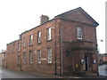
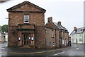
Buildings on Main Street and Longtown Road
The brick building (left) is the Police Station.
Image: © Mike Quinn
Taken: 3 Oct 2009
0.07 miles
2
Brampton police station
Brampton police station, Longtown Road, Brampton, Cumbria, which dates from 1902
Image: © Kevin Hale
Taken: 28 May 2010
0.08 miles
3
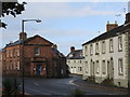
Police Station at Carlisle Road / Longtown Road junction
There is an OS benchmark Image on the right hand corner, right of a cable, of the building
Image: © Roger Templeman
Taken: 31 May 2019
0.09 miles
4
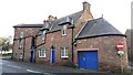
Police Station and associated buildings on SW side of Longtown Road
There is a 1902 date stone over the left hand door
Image: © Roger Templeman
Taken: 15 Feb 2023
0.09 miles
5
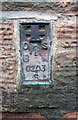
Benchmark on the Police Station, Longtown Road face
Ordnance Survey flush bracket (serial identifier S0203) benchmark levelled at 66.256m above Newlyn Datum in 1955
Image: © Roger Templeman
Taken: 31 May 2019
0.09 miles
6
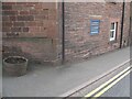
Corner of Brampton Police Station
The red sandstone Police Station sits in the angle between Carlisle Road and Longtown Road. On the corner of the wall facing Longtown Road there is an Ordnance Survey flush bracket benchmark (photograph Image).
Image: © Adrian Taylor
Taken: 30 Apr 2009
0.09 miles
7
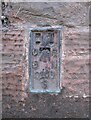
Benchmark, Brampton Police Station
Detail of the Ordnance Survey flush bracket benchmark on the wall of Brampton Police Station facing Longtown Road. The benchmark marks a height of 66.2564m above sea level (Ordnance Datum Newlyn) last levelled in 1955 and verified in 1972 (location photograph Image).
Image: © Adrian Taylor
Taken: 24 Jan 2008
0.09 miles
8
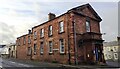
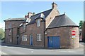
Police Station, formerly National School, at Carlisle Road / Longtown Road junction
Ordnance Survey documents indicate that a benchmark was levelled on the near corner of the building at 220.421 feet above Liverpool Datum in 1844 during the Carlisle to North Shields 1GL Survey. The surveyor's description was 'No. 34. Mark on South-east corner of Brampton National School-house ; 2.40 ft. above surface'
Image: © Roger Templeman
Taken: 15 Feb 2023
0.09 miles