IMAGES TAKEN NEAR TO
Howard Gardens, BRAMPTON, CA8 1AH
Introduction
This page details the photographs taken nearby to Howard Gardens, CA8 1AH by members of the Geograph project.
The Geograph project started in 2005 with the aim of publishing, organising and preserving representative images for every square kilometre of Great Britain, Ireland and the Isle of Man.

There are currently over 7.5m images from over14,400 individuals and you can help contribute to the project by visiting https://www.geograph.org.uk
Image Map (Loading...)


Getting Data...Please wait
Leaflet Map data © OpenStreetMap
Images are licensed for reuse under creativecommons.org/licenses/by-sa/2.0
Notes
- Clicking on the map will re-center to the selected point.
- The higher the marker number, the further away the image location is from the centre of the postcode.
Image Listing (130 Images Found)
Images are licensed for reuse under creativecommons.org/licenses/by-sa/2.0
Image
Details
Distance
1
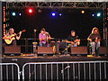
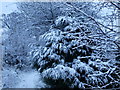
Brampton Live 2007
Last Nights Fun performing at the Brampton Live Festival 2007
Image: © Mark Taylor
Taken: 22 Jul 2007
0.08 miles
2
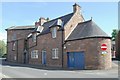
Row of houses on NW side of Carlisle Road opposite road junction
Ordnance Survey documents indicate that a benchmark was levelled on the front of a house here at 225.251 feet above Liverpool Datum in 1844 during the Carlisle to North Shields 1GL Survey. The surveyor's description was 'No. 33. Mark on front of house in Main-street, Brampton, at junction of roads ; 1.08 ft. above surface'
Image: © Roger Templeman
Taken: 15 Feb 2023
0.11 miles
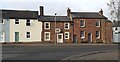
3
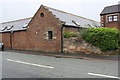
Buildings on Main Street and Longtown Road
The brick building (left) is the Police Station.
Image: © Mike Quinn
Taken: 3 Oct 2009
0.11 miles
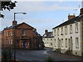
4
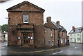
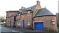
Brampton police station
Brampton police station, Longtown Road, Brampton, Cumbria, which dates from 1902
Image: © Kevin Hale
Taken: 28 May 2010
0.12 miles
5
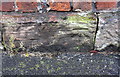
Benchmark on building at Townfoot Court, Carlisle Road
Ordnance Survey cut mark benchmark levelled at 69.296m above Newlyn Datum
Image: © Roger Templeman
Taken: 31 May 2019
0.12 miles
6
Townfoot Court building, Carlisle Road
There is an OS benchmark Image on the near corner of the building left of the black downpipe
Image: © Roger Templeman
Taken: 31 May 2019
0.12 miles
7
Police Station at Carlisle Road / Longtown Road junction
There is an OS benchmark Image on the right hand corner, right of a cable, of the building
Image: © Roger Templeman
Taken: 31 May 2019
0.12 miles
8
Police Station and associated buildings on SW side of Longtown Road
There is a 1902 date stone over the left hand door
Image: © Roger Templeman
Taken: 15 Feb 2023
0.12 miles
9

Brampton Live 2007
July was a wet month and the playing fields at William Howard School, Brampton, the site for Brampton Live Festival’s main marquee, became extremely muddy. Most of the damage was caused by a large tractor pulling cars on and off the field, an old grey Fergie wouldn’t have made half the mess.
Image: © Mark Taylor
Taken: 22 Jul 2007
0.12 miles