IMAGES TAKEN NEAR TO
Brackenlands, WIGTON, CA7 9JX
Introduction
This page details the photographs taken nearby to Brackenlands, CA7 9JX by members of the Geograph project.
The Geograph project started in 2005 with the aim of publishing, organising and preserving representative images for every square kilometre of Great Britain, Ireland and the Isle of Man.

There are currently over 7.5m images from over14,400 individuals and you can help contribute to the project by visiting https://www.geograph.org.uk
Image Map
Images are licensed for reuse under creativecommons.org/licenses/by-sa/2.0
Notes
- Clicking on the map will re-center to the selected point.
- The higher the marker number, the further away the image location is from the centre of the postcode.
Image Listing (19 Images Found)
Images are licensed for reuse under creativecommons.org/licenses/by-sa/2.0
Image
Details
Distance
1
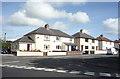
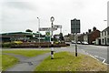
Housing on the southern approach to Wigton town centre
It is the B5304 - South End, Wigton.
Image: © Nigel Monckton
Taken: 2 Oct 2005
0.03 miles
2
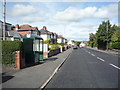
Bus stop and shelter on South End, Wigton
Looking north west.
Image: © JThomas
Taken: 17 Sep 2016
0.08 miles
4
Road junction with pinfold
The red sandstone walls in front of the petrol station are a reconstruction of the pinfold which once stood there - a pinfold was an enclosure to hold stray sheep.
Completed in 2009, it is the final work in the Sheepfolds arts project launched in 1996 http://www.sheepfoldscumbria.co.uk/ . Commissioned by Cumbria County Council, the sculptor Andy Goldsworthy has creatively reconstructed nearly 50 disused or ruined sheepfolds in Cumbria.
This view is from South End across the junction with Lowmoor Road.
Image: © Rose and Trev Clough
Taken: 4 Jun 2011
0.10 miles
5
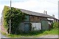
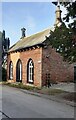
Outbuilding
On a lane off South End, behind the Mini Market.
Image: © Rose and Trev Clough
Taken: 4 Jun 2011
0.10 miles
6
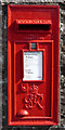
George VI postbox on South End, Wigton
Postbox No. CA7 330.
See Image] for context.
Image: © JThomas
Taken: 17 Sep 2016
0.11 miles
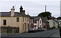
7
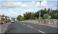
South End, Wigton
Showing position of Postbox No. CA7 330.
See Image] for postbox.
Image: © JThomas
Taken: 17 Sep 2016
0.11 miles
8
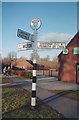
Old Direction Sign - Signpost by the B5304, Wigton
Annulus finial - 3 arms; Cumberland named halo by the B5304, in parish of Wigton (Allerdale District), by the former Co-op, now medical centre, at junction with the B5305 and Longthwaite Road.
Surveyed
Milestone Society National ID: CU_NY2547
Image: © Milestone Society
Taken: Unknown
0.11 miles
9
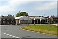
Huntington's Garage, South End
Garage and showroom, closed for a few years and up for sale.
Image: © Rose and Trev Clough
Taken: 4 Jun 2011
0.12 miles