IMAGES TAKEN NEAR TO
Burnfoot, WIGTON, CA7 9HU
Introduction
This page details the photographs taken nearby to Burnfoot, CA7 9HU by members of the Geograph project.
The Geograph project started in 2005 with the aim of publishing, organising and preserving representative images for every square kilometre of Great Britain, Ireland and the Isle of Man.

There are currently over 7.5m images from over14,400 individuals and you can help contribute to the project by visiting https://www.geograph.org.uk
Image Map
Images are licensed for reuse under creativecommons.org/licenses/by-sa/2.0
Notes
- Clicking on the map will re-center to the selected point.
- The higher the marker number, the further away the image location is from the centre of the postcode.
Image Listing (38 Images Found)
Images are licensed for reuse under creativecommons.org/licenses/by-sa/2.0
Image
Details
Distance
1
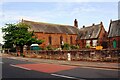
St Cuthbert's Church beside B5303
There is a milestone Image against the roadside wall in the middle of the image
Image: © Luke Shaw
Taken: 16 Jul 2019
0.01 miles
2
St Cuthbert's Church on NW side of B5303
There is an Ordnance Survey flush bracket benchmark Image on a buttress on the left hand side of the church at its front corner
Image: © Luke Shaw
Taken: 16 Jul 2019
0.02 miles
3
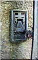
Benchmark on St Cuthbert's Catholic Church
Ordnance Survey flush bracket (serial identifier S8299) benchmark described on the Bench Mark Database at www.bench-marks.org.uk/bm13197
Image: © Roger Templeman
Taken: 3 Aug 2019
0.02 miles
4
Milestone on NW side of King Street (B5303)
Ordnance Survey documents indicate that in 1844 a benchmark was levelled at 72.133 feet above Liverpool Datum on top of this milestone. See www.bench-marks.org.uk/bm33894 for details
Image: © Luke Shaw
Taken: 16 Jul 2019
0.02 miles
5
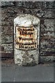
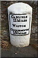
Old Milestone by the B5303 in Wigton
Metal plate attached to stone post by the B5303 (was A595), in parish of WIGTON (ALLERDALE District), opposite Accrington Terrace, in front of St Cuthbert's Presbytery, in Presbytery wall, on North side of road. Carlisle red stone and curved plate, erected by the Cockermouth & Carlisle turnpike trust in the 19th century.
Inscription reads:-
CARLISLE
11 MILES
WIGTON
COCKERMOUTH
15½ MILES
Grade II Listed. List Entry Number: 1144588
https://historicengland.org.uk/listing/the-list/list-entry/1144588
Milestone Society National ID: CU_CLCM11a.
Image: © CF Smith
Taken: 16 Sep 2005
0.02 miles
6
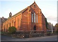
St Cuthbert's RC Church, Burnfoot, Wigton
Designed by Bonomi and built of red sandstone in 1837. Enlarged in 1857.
Image: © Humphrey Bolton
Taken: 1 Nov 2006
0.05 miles
7
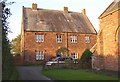
Hope House, Burnfoot, Wigton
Partly behind St Cuthbert's RC Church. This looks to be a pair of large semi-detached houses of the 19C.
Image: © Humphrey Bolton
Taken: 1 Nov 2006
0.05 miles
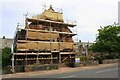
8
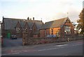
Convent, Burnfoot, Wigton
Next to St Cuthbert's RC Church.
Image: © Humphrey Bolton
Taken: 1 Nov 2006
0.05 miles
9

ATS Wigton
This former garage in Wigton is now an ATS tyre centre.
Image: © Philip Halling
Taken: 27 Aug 2008
0.07 miles
10
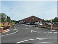
Lidl supermarket
Opened in 2011. A garage previously on the site was demolished - see Image . A new mini- roundabout was installed as part of the development.
The photo was taken from a bus.
Image: © Rose and Trev Clough
Taken: 14 Jun 2011
0.07 miles