IMAGES TAKEN NEAR TO
Standingstone Heights, WIGTON, CA7 9DS
Introduction
This page details the photographs taken nearby to Standingstone Heights, CA7 9DS by members of the Geograph project.
The Geograph project started in 2005 with the aim of publishing, organising and preserving representative images for every square kilometre of Great Britain, Ireland and the Isle of Man.

There are currently over 7.5m images from over14,400 individuals and you can help contribute to the project by visiting https://www.geograph.org.uk
Image Map
Images are licensed for reuse under creativecommons.org/licenses/by-sa/2.0
Notes
- Clicking on the map will re-center to the selected point.
- The higher the marker number, the further away the image location is from the centre of the postcode.
Image Listing (42 Images Found)
Images are licensed for reuse under creativecommons.org/licenses/by-sa/2.0
Image
Details
Distance
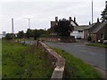
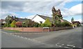
1
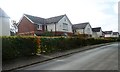
Houses in Standingstone Heights, Wigton
A fairly new development on the south side of Cross Lane.
Image: © Christine Johnstone
Taken: 14 Oct 2014
0.04 miles
2
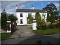
The Grange, Cross Lane, Wigton
Facing south and basking in the sun.
Image: © Christine Johnstone
Taken: 14 Oct 2014
0.06 miles
3
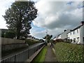
Raised pavement, Cross Lane, Wigton
On the north wide, at the eastern end.
Image: © Christine Johnstone
Taken: 14 Oct 2014
0.07 miles
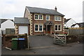
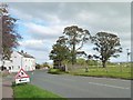
5
Standingstone
It is not clear where the standing stone of the name is now. Locally this area is usually referred to as Cross Lanes. The chimney of Innovia films, in the centre of nearby Wigton, can be seen on the right of the picture.
Image: © Nigel Monckton
Taken: 2 Oct 2005
0.08 miles
6

Roadworks on Cross Lane, Wigton
At the eastern end, looking west.
Image: © Christine Johnstone
Taken: 14 Oct 2014
0.08 miles
7
Trees at the junction, Standingstone
At the eastern end of Cross Lane, just north of Wigton.
Image: © Christine Johnstone
Taken: 14 Oct 2014
0.10 miles
8
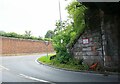
Junction of A596 and Station Road from railway bridge CBC3/87
There is an Ordnance Survey benchmark Image on the bridge wing left of the traffic cone
Image: © Luke Shaw
Taken: 16 Jul 2019
0.10 miles
9
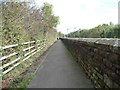
Raised footpath, north side, A596, Wigton
Linked by a footbridge to the northside platform of Wigton railway station.
Image: © Christine Johnstone
Taken: 14 Oct 2014
0.11 miles
10
Entrance to Grange Gardens, Cross Lane, Wigton
A road of bungalows behind the houses on the north side of Cross Lane.
Image: © Christine Johnstone
Taken: 14 Oct 2014
0.12 miles