IMAGES TAKEN NEAR TO
Water Street, WIGTON, CA7 9BS
Introduction
This page details the photographs taken nearby to Water Street, CA7 9BS by members of the Geograph project.
The Geograph project started in 2005 with the aim of publishing, organising and preserving representative images for every square kilometre of Great Britain, Ireland and the Isle of Man.

There are currently over 7.5m images from over14,400 individuals and you can help contribute to the project by visiting https://www.geograph.org.uk
Image Map (Loading...)


Getting Data...Please wait
Leaflet Map data © OpenStreetMap
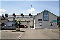
Images are licensed for reuse under creativecommons.org/licenses/by-sa/2.0
Notes
- Clicking on the map will re-center to the selected point.
- The higher the marker number, the further away the image location is from the centre of the postcode.
Image Listing (126 Images Found)
Images are licensed for reuse under creativecommons.org/licenses/by-sa/2.0
Image
Details
Distance
1
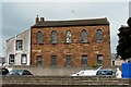
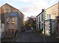
Former United Reformed Church
Seen across the end of Water Street car park (with recycling facilities on the right). The former manse, with grey rendered walls, adjoins the red sandstone church. The front of the building is shown here Image .
The church opened in 1834, and was one of the largest Nonconformist places of worship in West Cumbria. A dwindling congregation and expense of upkeep led to the last service being held in 2009, and the church put up for sale. The new owners of the grade II listed building plan to transform it into a computer museum and science & engineering centre http://t-lcarchive.org/index.php?option=com_content&view=article&id=1191&Itemid=472 .
Image: © Rose and Trev Clough
Taken: 4 Jun 2011
0.02 miles
2
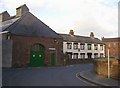
Former Almshouses, Church Street
Now three private houses. Dated 1723, with an inscription in Latin, which translates John Thomlinson assisted by his brother Robert provided pensions and erected this matron's college. The window and door surrounds are 19C. The building housed six widows of clergy; each with 3 rooms and an annual pension of £9. It was sold by the Charity Commissioners in 1884. The industrial building on the left looks interesting.
Image: © Humphrey Bolton
Taken: 1 Nov 2006
0.04 miles
3
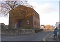
United Reformed Church, Water Street, Wigton
An inscription states that this was opened on October 8th 1834. It is Grade II listed. The manse at the rear has cement-rendered walls.
Image: © Humphrey Bolton
Taken: 1 Nov 2006
0.04 miles
4
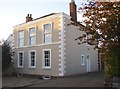
Donaldson House, Birdcage Walk, Wigton
Built in 1805. An unusual design with an insignificant doorway at the side, and first-floor windows larger than the ground-floor ones.
Image: © Humphrey Bolton
Taken: 1 Nov 2006
0.04 miles
5
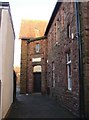
Joinery, Birdcage Walk, Wigton
A plaque on the side states that this building is a former 18C watermill, which was working up to the 1920s. However the plan on the plaque suggest that the mill was behind Southward House on the right.
Image: © Humphrey Bolton
Taken: 1 Nov 2006
0.05 miles
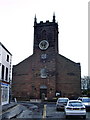
7
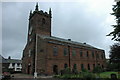
St Mary's Church, Wigton
St Mary's Church in Wigton dates from 1788 and replaced an earlier church on the same site.
Image: © Philip Halling
Taken: 27 Aug 2008
0.05 miles
8
Kingdom Hall of Jehovah's Witnesses, Wigton
In an alley between King Street and High Street.
Image: © Humphrey Bolton
Taken: 1 Nov 2006
0.05 miles
9
Wigton Market Hall
Work to extend and refurbish the hall started in 2007, and it was officially reopened in 2010. Markets are held a couple of days a week, and the building is used for concerts, meetings and events.
Market Hall website : http://www.themarkethall.org.uk/index.html .
Image: © Rose and Trev Clough
Taken: 14 Jun 2011
0.05 miles
10
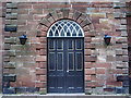
St Mary's Parish Church, Wigton, Doorway
Image: © Alexander P Kapp
Taken: 17 Apr 2008
0.05 miles