IMAGES TAKEN NEAR TO
WIGTON, CA7 9AU
Introduction
This page details the photographs taken nearby to CA7 9AU by members of the Geograph project.
The Geograph project started in 2005 with the aim of publishing, organising and preserving representative images for every square kilometre of Great Britain, Ireland and the Isle of Man.

There are currently over 7.5m images from over14,400 individuals and you can help contribute to the project by visiting https://www.geograph.org.uk
Image Map
Images are licensed for reuse under creativecommons.org/licenses/by-sa/2.0
Notes
- Clicking on the map will re-center to the selected point.
- The higher the marker number, the further away the image location is from the centre of the postcode.
Image Listing (122 Images Found)
Images are licensed for reuse under creativecommons.org/licenses/by-sa/2.0
Image
Details
Distance
1
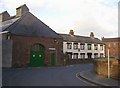
Former Almshouses, Church Street
Now three private houses. Dated 1723, with an inscription in Latin, which translates John Thomlinson assisted by his brother Robert provided pensions and erected this matron's college. The window and door surrounds are 19C. The building housed six widows of clergy; each with 3 rooms and an annual pension of £9. It was sold by the Charity Commissioners in 1884. The industrial building on the left looks interesting.
Image: © Humphrey Bolton
Taken: 1 Nov 2006
0.00 miles
2
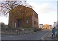
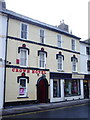
United Reformed Church, Water Street, Wigton
An inscription states that this was opened on October 8th 1834. It is Grade II listed. The manse at the rear has cement-rendered walls.
Image: © Humphrey Bolton
Taken: 1 Nov 2006
0.00 miles
3
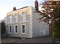
Donaldson House, Birdcage Walk, Wigton
Built in 1805. An unusual design with an insignificant doorway at the side, and first-floor windows larger than the ground-floor ones.
Image: © Humphrey Bolton
Taken: 1 Nov 2006
0.00 miles
4
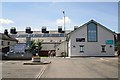
Wigton Market Hall
Work to extend and refurbish the hall started in 2007, and it was officially reopened in 2010. Markets are held a couple of days a week, and the building is used for concerts, meetings and events.
Market Hall website : http://www.themarkethall.org.uk/index.html .
Image: © Rose and Trev Clough
Taken: 14 Jun 2011
0.02 miles
6
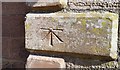
Ordnance Survey 1GL Bolt
This OS Bolt can be found on the west face of St Mary's Church. It marks a point 33.705m above mean sea level.
Image: © Adrian Dust
Taken: 26 Mar 2018
0.02 miles
8

Doorway on west face of St Mary's Church
There is an Ordnance Survey benchmark Image on the fifth quoin above ground at the left hand edge of the doorway jut
Image: © Luke Shaw
Taken: 23 Jul 2019
0.02 miles
10
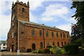
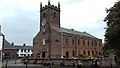
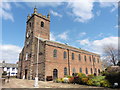
St Mary's Church
There are Ordnance Survey benchmarks on the near corner Image and on the west face Image of the church. A bolt and flagstaff on the tower roof were used as components of a triangulation station (see http://trigpointing.uk/trig/16534 ) in 1953: the flagstaff has been relocated in the church grounds.
Image: © Luke Shaw
Taken: 23 Jul 2019
0.02 miles