IMAGES TAKEN NEAR TO
Station Road, WIGTON, CA7 9AJ
Introduction
This page details the photographs taken nearby to Station Road, CA7 9AJ by members of the Geograph project.
The Geograph project started in 2005 with the aim of publishing, organising and preserving representative images for every square kilometre of Great Britain, Ireland and the Isle of Man.

There are currently over 7.5m images from over14,400 individuals and you can help contribute to the project by visiting https://www.geograph.org.uk
Image Map
Images are licensed for reuse under creativecommons.org/licenses/by-sa/2.0
Notes
- Clicking on the map will re-center to the selected point.
- The higher the marker number, the further away the image location is from the centre of the postcode.
Image Listing (133 Images Found)
Images are licensed for reuse under creativecommons.org/licenses/by-sa/2.0
Image
Details
Distance
1
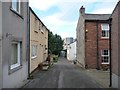
Northern end, Meetinghouse Lane, Wigton
The sandstone building on the right [east] has a Masonic plaque from the 1850s.
Image: © Christine Johnstone
Taken: 14 Oct 2014
0.03 miles
2
Tiny Tots Nursery, Wigton
In Meetinghouse Lane, on the north side of King Street.
Image: © Christine Johnstone
Taken: 14 Oct 2014
0.06 miles
3
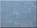
Wigton from the west
Bypassed by the A596 heading from Maryport to Carlisle.
Image: © M J Richardson
Taken: 9 Oct 2012
0.07 miles
4
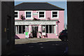
The Glasshouse, Wigton
Pink restaurant on Wheatsheaf Lane.
Image: © Stephen McKay
Taken: 2 Oct 2014
0.08 miles
5
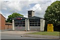
Wigton fire station
Wigton fire station, Station Road, Wigton, Cumbria
Image: © Kevin Hale
Taken: 28 May 2010
0.08 miles
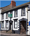
6
No. 27-28 King Street (Gladrags) at New Street junction
There is an Ordnance Survey benchmark Image on the near corner, right hand face, of the shop
Image: © Luke Shaw
Taken: 23 Jul 2019
0.08 miles
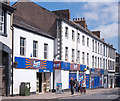
7
Former HSBC Bank, Wigton - May 2017
Formerly the Cumberland Union Bank and appearing on the 1864 OS Map, it became part of the Midland Bank and later HSBC. An undated notice in the window informs local HSBC customers they must now travel to Carlisle.
Image: © The Carlisle Kid
Taken: 31 May 2017
0.09 miles
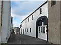
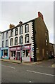
8
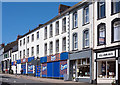
Former "Black Swan" pub and former "Queens Head Hotel" - Wigton - May 2017 (1)
Situated on King Street just below the closed HSBC Bank (see: Image] ) both pre-date the 1864 OS Map. The small two-storey "Black Swan" was once cleverly painted to represent stone blocks. Neither buildings are specifically named on the 1892 OS Map, so may have closed before the end of the 19th Century. Local historian Trevor Grahamslaw ("Wigton Through Time" - Amberley Publishing 2010) records that the hotel eventually became a Co-Operative store, while both buildings became Haldane's grocery store. Current use is clear!
See also: Image] .
Photograph is for record only - I have no connection with any business seen in the view and cannot advise on their products or services.
Image: © The Carlisle Kid
Taken: 31 May 2017
0.09 miles
9
Former "Black Swan" pub and former "Queens Head Hotel" - Wigton - May 2017 (2)
For information on these buildings, see: Image
Image: © The Carlisle Kid
Taken: 31 May 2017
0.09 miles
10
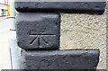
Benchmark on No.27-28 King Street
Ordnance Survey cut mark benchmark described on the Bench Mark Database at www.bench-marks.org.uk/bm106146
Image: © Luke Shaw
Taken: 23 Jul 2019
0.09 miles