IMAGES TAKEN NEAR TO
Redmayne Close, WIGTON, CA7 9AF
Introduction
This page details the photographs taken nearby to Redmayne Close, CA7 9AF by members of the Geograph project.
The Geograph project started in 2005 with the aim of publishing, organising and preserving representative images for every square kilometre of Great Britain, Ireland and the Isle of Man.

There are currently over 7.5m images from over14,400 individuals and you can help contribute to the project by visiting https://www.geograph.org.uk
Image Map
Images are licensed for reuse under creativecommons.org/licenses/by-sa/2.0
Notes
- Clicking on the map will re-center to the selected point.
- The higher the marker number, the further away the image location is from the centre of the postcode.
Image Listing (132 Images Found)
Images are licensed for reuse under creativecommons.org/licenses/by-sa/2.0
Image
Details
Distance
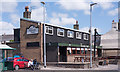
1
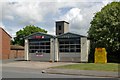
Wigton fire station
Wigton fire station, Station Road, Wigton, Cumbria
Image: © Kevin Hale
Taken: 28 May 2010
0.05 miles
2
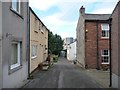
Northern end, Meetinghouse Lane, Wigton
The sandstone building on the right [east] has a Masonic plaque from the 1850s.
Image: © Christine Johnstone
Taken: 14 Oct 2014
0.07 miles
3
Throstle Nest, King Street, Wigton
Image: © Alexander P Kapp
Taken: 17 Apr 2008
0.08 miles
4
Tiny Tots Nursery, Wigton
In Meetinghouse Lane, on the north side of King Street.
Image: © Christine Johnstone
Taken: 14 Oct 2014
0.09 miles
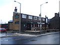
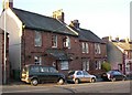
5
The Throstles Nest, Wigton - May 2017
A relatively new pub, built and opened by the State Management Scheme on 5 July 1960. It may have replaced an earlier pub to the left in this view, but available sources are vague.
Photograph is for record only - I have no connection with this business and cannot advise on its products or services.
Image: © The Carlisle Kid
Taken: 31 May 2017
0.09 miles
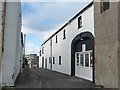
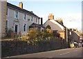
6
The Black-a-moor Hotel, King Street, Wigton
A pleasant red-sandstone front, next to a pair of houses of the same material but with arched window and door surrounds.
Image: © Humphrey Bolton
Taken: 1 Nov 2006
0.09 miles
7
House, King Street, Wigton
This house has an elaborately decorated doorway. It is perched on high ground, much higher than the Black-a-moor next door, which must presumably be on a site dug out of the hillside.
Image: © Humphrey Bolton
Taken: 1 Nov 2006
0.09 miles
8
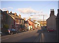
The lower end of King Street, Wigton
Some people like to liven up old terrace houses!
Image: © Humphrey Bolton
Taken: 1 Nov 2006
0.09 miles
9
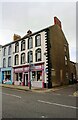
No. 27-28 King Street (Gladrags) at New Street junction
There is an Ordnance Survey benchmark Image on the near corner, right hand face, of the shop
Image: © Luke Shaw
Taken: 23 Jul 2019
0.10 miles
10
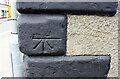
Benchmark on No.27-28 King Street
Ordnance Survey cut mark benchmark described on the Bench Mark Database at www.bench-marks.org.uk/bm106146
Image: © Luke Shaw
Taken: 23 Jul 2019
0.10 miles