IMAGES TAKEN NEAR TO
Mealo Hill, WIGTON, CA7 8PD
Introduction
This page details the photographs taken nearby to Mealo Hill, CA7 8PD by members of the Geograph project.
The Geograph project started in 2005 with the aim of publishing, organising and preserving representative images for every square kilometre of Great Britain, Ireland and the Isle of Man.

There are currently over 7.5m images from over14,400 individuals and you can help contribute to the project by visiting https://www.geograph.org.uk
Image Map
Images are licensed for reuse under creativecommons.org/licenses/by-sa/2.0
Notes
- Clicking on the map will re-center to the selected point.
- The higher the marker number, the further away the image location is from the centre of the postcode.
Image Listing (9 Images Found)
Images are licensed for reuse under creativecommons.org/licenses/by-sa/2.0
Image
Details
Distance
3
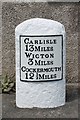
Old Milestone by the former A595 in Bolton Low Houses
Metal plate attached to stone post by the UC road (was A595), in parish of BOLTONS (ALLERDALE District), Bolton Low Houses, by Rose Garth, opposite Solway View, in tarmac front of house, on North side of road. Carlisle red stone and curved plate, erected by the Cockermouth & Carlisle turnpike trust in the 19th century.
Inscription reads:-
CARLISLE
13 MILES
WIGTON
3 MILES
COCKERMOUTH
12½ MILES
Carved benchmark and rivet on top.
Grade II Listed. List Entry Number: 1144466
https://historicengland.org.uk/listing/the-list/list-entry/1144466
Milestone Society National ID: CU_CLCM13.
Image: © T Moore
Taken: 20 Jun 2014
0.03 miles
4
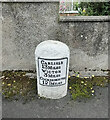
Old Milestone by the former A595 in Bolton Low Houses
Metal plate attached to stone post by the UC road (was A595), in parish of BOLTONS (ALLERDALE District), Bolton Low Houses, by Rose Garth, opposite Solway View, in tarmac front of house, on North side of road. Carlisle red stone and curved plate, erected by the Cockermouth & Carlisle turnpike trust in the 19th century.
Inscription reads:-
CARLISLE
13 MILES
WIGTON
3 MILES
COCKERMOUTH
12½ MILES
Carved benchmark and rivet on top.
Grade II Listed. List Entry Number: 1144466 https://historicengland.org.uk/listing/the-list/list-entry/1144466
Milestone Society National ID: CU_CLCM13.
Image: © Barbara Todd
Taken: 18 Sep 2023
0.03 miles
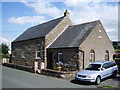
5
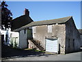
Outside steps
Outside steps to the upper floor of what was a small barn.
Image: © Alexander P Kapp
Taken: 8 Aug 2007
0.05 miles
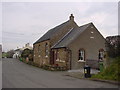
6
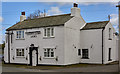
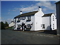
Oddfellows Arms, Bolton-low-Houses - April 2017 (1)
Believed to date from 1737, the Oddfellows Arms came under the grasp of the Carlisle State Management Scheme, although the exact date has not been found. The Scheme records its sale in 1973 for £4,750 and it is still trading.
See also: Image] and Image] .
Photograph is for record only - I have no connection with this business and cannot advise on its products or services.
Image: © The Carlisle Kid
Taken: 12 Apr 2017
0.09 miles
7
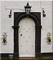
Oddfellows Arms, Bolton-low-Houses - April 2017 (2)
Entrance to the pub.
For information on this building, see: Image] .
Image: © The Carlisle Kid
Taken: 12 Apr 2017
0.09 miles
9
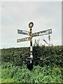
Direction Sign – Signpost near Brough Hill, Bolton Low Houses
Located on the southeast side of the junction at Brough Hill, at the south end of Bolton Low Houses. Boltons parish. 3 arms and annulus finial.
Milestone Society National ID: CU_NY2344
Image: © B Todd
Taken: 17 Sep 2023
0.20 miles